IMAGES TAKEN NEAR TO
Newtown Road, NEWRY, BT35 7PL
Introduction
This page details the photographs taken nearby to Newtown Road, BT35 7PL by members of the Geograph project.
The Geograph project started in 2005 with the aim of publishing, organising and preserving representative images for every square kilometre of Great Britain, Ireland and the Isle of Man.

There are currently over 7.5m images from over14,400 individuals and you can help contribute to the project by visiting https://www.geograph.org.uk
Image Map
Images are licensed for reuse under creativecommons.org/licenses/by-sa/2.0
Notes
- Clicking on the map will re-center to the selected point.
- The higher the marker number, the further away the image location is from the centre of the postcode.
Image Listing (7 Images Found)
Images are licensed for reuse under creativecommons.org/licenses/by-sa/2.0
Image
Details
Distance
1
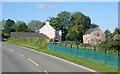
Farmhouse and outbuildings on the North side of the A25
These are located about a mile West of Belleek.
Image: © Eric Jones
Taken: 7 Jun 2019
0.07 miles
2
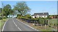
Farm bungalow alongside the A25 west of Belleek
Image: © Eric Jones
Taken: 7 Jun 2019
0.11 miles
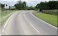
3
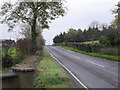
Newtown Road near Belleek
Just on the Newtown side of Belleek village.
Image: © Dean Molyneaux
Taken: 18 Oct 2009
0.14 miles
4
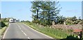
Asbestos roofed cottage on the A25 outside Belleek
This homestead is now derelict.
Image: © Eric Jones
Taken: 7 Jun 2019
0.14 miles
5
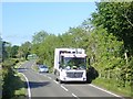
A Newry Mourne and Down District Council Refuse Collection lorry on the A25
This image was taken between the village of Belleek and Irwin's Cross Roads.
Image: © Eric Jones
Taken: 7 Jun 2019
0.14 miles
6
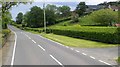
Trimmed hedges alongside the A25 West of Belleek
Image: © Eric Jones
Taken: 7 Jun 2019
0.15 miles
7
Speed camera warning on the A25 between Irwin's Cross Roads and Belleek
Image: © Eric Jones
Taken: 7 Jun 2019
0.17 miles