IMAGES TAKEN NEAR TO
Keggall Road, NEWRY, BT35 7LD
Introduction
This page details the photographs taken nearby to Keggall Road, BT35 7LD by members of the Geograph project.
The Geograph project started in 2005 with the aim of publishing, organising and preserving representative images for every square kilometre of Great Britain, Ireland and the Isle of Man.

There are currently over 7.5m images from over14,400 individuals and you can help contribute to the project by visiting https://www.geograph.org.uk
Image Map
Images are licensed for reuse under creativecommons.org/licenses/by-sa/2.0
Notes
- Clicking on the map will re-center to the selected point.
- The higher the marker number, the further away the image location is from the centre of the postcode.
Image Listing (7 Images Found)
Images are licensed for reuse under creativecommons.org/licenses/by-sa/2.0
Image
Details
Distance
2
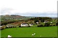
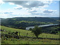
Rural settlement on the Keggall Road
Keggall Wood which overlooks Camlough lake forms the background. This image was taken from the south-western end of Mountain Road.
Image: © Eric Jones
Taken: 11 Apr 2014
0.20 miles
4
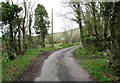
Derelict building on the east side of Mountain Road
Image: © Eric Jones
Taken: 11 Apr 2014
0.21 miles
5
Camlough Lake
View from 2/3 way up Camlough Mountain
Image: © Harry McLoughlin
Taken: 10 Aug 2003
0.22 miles
6

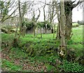
Derelict farmhouse below the Mountain Road
Image: © Eric Jones
Taken: 11 Apr 2014
0.23 miles
7
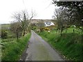
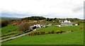
Modern house on Mountain Road, Camlough
A spur of Camlough Mountain forms the background.
Image: © Eric Jones
Taken: 11 Apr 2014
0.25 miles