IMAGES TAKEN NEAR TO
Gordons Lane, NEWRY, BT35 7LA
Introduction
This page details the photographs taken nearby to Gordons Lane, BT35 7LA by members of the Geograph project.
The Geograph project started in 2005 with the aim of publishing, organising and preserving representative images for every square kilometre of Great Britain, Ireland and the Isle of Man.

There are currently over 7.5m images from over14,400 individuals and you can help contribute to the project by visiting https://www.geograph.org.uk
Image Map
Images are licensed for reuse under creativecommons.org/licenses/by-sa/2.0
Notes
- Clicking on the map will re-center to the selected point.
- The higher the marker number, the further away the image location is from the centre of the postcode.
Image Listing (3 Images Found)
Images are licensed for reuse under creativecommons.org/licenses/by-sa/2.0
Image
Details
Distance
1
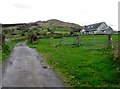
Bungalow on Gordon's Lane, Camlough
The hill in the background is Camlough Mountain.
Image: © Eric Jones
Taken: 11 Apr 2014
0.01 miles
3
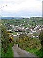
Gordons Lane descending towards Camlough
Image: © Eric Jones
Taken: 11 Apr 2014
0.12 miles