IMAGES TAKEN NEAR TO
Eshwary Hill, NEWRY, BT35 7HZ
Introduction
This page details the photographs taken nearby to Eshwary Hill, BT35 7HZ by members of the Geograph project.
The Geograph project started in 2005 with the aim of publishing, organising and preserving representative images for every square kilometre of Great Britain, Ireland and the Isle of Man.

There are currently over 7.5m images from over14,400 individuals and you can help contribute to the project by visiting https://www.geograph.org.uk
Image Map
Images are licensed for reuse under creativecommons.org/licenses/by-sa/2.0
Notes
- Clicking on the map will re-center to the selected point.
- The higher the marker number, the further away the image location is from the centre of the postcode.
Image Listing (4 Images Found)
Images are licensed for reuse under creativecommons.org/licenses/by-sa/2.0
Image
Details
Distance
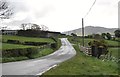
1
Gallops on the Carrickcroppan Road
The railings of the gallops can be seen on the skyline.
Image: © Eric Jones
Taken: 15 May 2012
0.18 miles
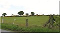
2
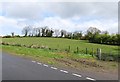
Farm land north of Carrickcroppan Road
This is an area mainly of pastoral farming.
Image: © Eric Jones
Taken: 15 May 2012
0.20 miles
3
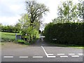
Entrance into Eshwary Hill road off Carrickcroppan Road
Image: © Eric Jones
Taken: 15 May 2012
0.24 miles