IMAGES TAKEN NEAR TO
Chapel Road, NEWRY, BT35 7HN
Introduction
This page details the photographs taken nearby to Chapel Road, BT35 7HN by members of the Geograph project.
The Geograph project started in 2005 with the aim of publishing, organising and preserving representative images for every square kilometre of Great Britain, Ireland and the Isle of Man.

There are currently over 7.5m images from over14,400 individuals and you can help contribute to the project by visiting https://www.geograph.org.uk
Image Map
Images are licensed for reuse under creativecommons.org/licenses/by-sa/2.0
Notes
- Clicking on the map will re-center to the selected point.
- The higher the marker number, the further away the image location is from the centre of the postcode.
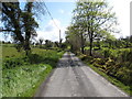
Image Listing (4 Images Found)
Images are licensed for reuse under creativecommons.org/licenses/by-sa/2.0
Image
Details
Distance
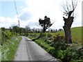
1

A bend near the north end of Carrowbane Road
Here the road weaves through drumlins.
Image: © Eric Jones
Taken: 15 May 2012
0.18 miles
3
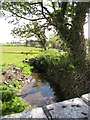
Stream running alongside Eshwary Road in Tullyhappy TD
The stream here has just emerge from a culvert under Eshwary Road and, in the foreground, is about flow under the Chapel Road bridge.
Image: © Eric Jones
Taken: 15 May 2012
0.25 miles