IMAGES TAKEN NEAR TO
Divernagh Road, NEWRY, BT35 7BW
Introduction
This page details the photographs taken nearby to Divernagh Road, BT35 7BW by members of the Geograph project.
The Geograph project started in 2005 with the aim of publishing, organising and preserving representative images for every square kilometre of Great Britain, Ireland and the Isle of Man.

There are currently over 7.5m images from over14,400 individuals and you can help contribute to the project by visiting https://www.geograph.org.uk
Image Map
Images are licensed for reuse under creativecommons.org/licenses/by-sa/2.0
Notes
- Clicking on the map will re-center to the selected point.
- The higher the marker number, the further away the image location is from the centre of the postcode.
Image Listing (5 Images Found)
Images are licensed for reuse under creativecommons.org/licenses/by-sa/2.0
Image
Details
Distance
1
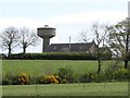
Divernagh Water Tower
This is a prominent local landmark.
Image: © Eric Jones
Taken: 15 May 2012
0.04 miles
2
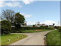
Divernagh Road at the junction with a minor lane linking it with Chapel Road
The Divernagh Water Tower can be seen in the background right.
Image: © Eric Jones
Taken: 15 May 2012
0.09 miles
3
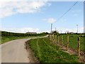
Divernagh Road NNE of Divernagh Orange Hall
Image: © Eric Jones
Taken: 15 May 2012
0.16 miles
4
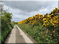
Whin hedge alongside a narrow lane linking Divernagh Road and Chapel Road
This lane is primarily an access lane to a farm from Divernagh Road, beyond which it becomes unsuitable for anything but a tractor, before again improving towards its western end.
Image: © Eric Jones
Taken: 15 May 2012
0.17 miles
5
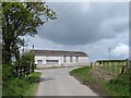
Divernagh Orange Hall, near to Bessbrook
The windows and doors of Orange Halls in the border areas are well secured as vandalism with sectarian connotations does occur. During 2013 the PSNI dealt with eighteen reported serious attacks on Orange property, including arson.
Image: © Eric Jones
Taken: 15 May 2012
0.20 miles