IMAGES TAKEN NEAR TO
Eshwary Road, NEWRY, BT35 7BN
Introduction
This page details the photographs taken nearby to Eshwary Road, BT35 7BN by members of the Geograph project.
The Geograph project started in 2005 with the aim of publishing, organising and preserving representative images for every square kilometre of Great Britain, Ireland and the Isle of Man.

There are currently over 7.5m images from over14,400 individuals and you can help contribute to the project by visiting https://www.geograph.org.uk
Image Map
Images are licensed for reuse under creativecommons.org/licenses/by-sa/2.0
Notes
- Clicking on the map will re-center to the selected point.
- The higher the marker number, the further away the image location is from the centre of the postcode.
Image Listing (8 Images Found)
Images are licensed for reuse under creativecommons.org/licenses/by-sa/2.0
Image
Details
Distance
2
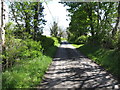
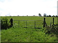
Unnamed lane linking Eshwary Road and Barrons Hill
It would appear that this little used lane is favoured by fly tippers.
Image: © Eric Jones
Taken: 15 May 2012
0.08 miles
4
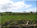
Undulating countryside west of Divernagh Road, Bessbrook
Image: © Eric Jones
Taken: 15 May 2012
0.11 miles
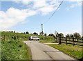
6
Rural settlement in Divernagh TD
These houses are located at the north-eastern end of Eshwary Road.
Image: © Eric Jones
Taken: 15 May 2012
0.16 miles
7
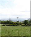
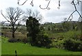
11kv power lines south of Eshwary Road
The village of Bessbrook can be seen in the background. The Mournes form the background.
Image: © Eric Jones
Taken: 15 May 2012
0.16 miles
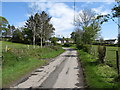
8
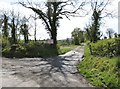
The junction of Eshwary Road and Divernagh Road near Bessbrook
Image: © Eric Jones
Taken: 15 May 2012
0.23 miles