IMAGES TAKEN NEAR TO
Convent Hill, NEWRY, BT35 7AP
Introduction
This page details the photographs taken nearby to Convent Hill, BT35 7AP by members of the Geograph project.
The Geograph project started in 2005 with the aim of publishing, organising and preserving representative images for every square kilometre of Great Britain, Ireland and the Isle of Man.

There are currently over 7.5m images from over14,400 individuals and you can help contribute to the project by visiting https://www.geograph.org.uk
Image Map
Images are licensed for reuse under creativecommons.org/licenses/by-sa/2.0
Notes
- Clicking on the map will re-center to the selected point.
- The higher the marker number, the further away the image location is from the centre of the postcode.
Image Listing (8 Images Found)
Images are licensed for reuse under creativecommons.org/licenses/by-sa/2.0
Image
Details
Distance
1
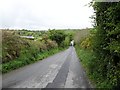
Descending Divernagh Road from the direction of Bessbrook
Image: © Eric Jones
Taken: 15 May 2012
0.02 miles
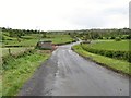
2
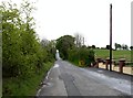
Divernagh Road ascending in the direction of the village of Bessbrook
Image: © Eric Jones
Taken: 15 May 2012
0.08 miles
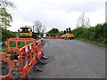
4
Water Main Laying on Mcclenaghans Road
The houses in the background are on Divernagh Road.
Image: © Eric Jones
Taken: 15 May 2012
0.10 miles
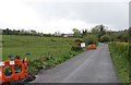
5
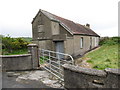
Disused hall facing the junction with Ballynabee Road
Image: © Eric Jones
Taken: 15 May 2012
0.18 miles
6
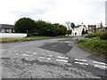
The entrance to Ballynabee Road, Bessbrook
The image was taken from Divernagh Road
Image: © Eric Jones
Taken: 15 May 2012
0.19 miles
7
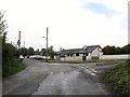
The top of Divernagh Road
Divernagh Road becomes Convent Gardens after the junction (seen on the right) with Ballynabee Road.
Image: © Eric Jones
Taken: 15 May 2012
0.20 miles
8
Mcclenaghans Road at the junction with McShane Road
Image: © Eric Jones
Taken: 15 May 2012
0.25 miles