IMAGES TAKEN NEAR TO
Demoan Villas, Newry Road, NEWRY, BT35 6TL
Introduction
This page details the photographs taken nearby to Demoan Villas, Newry Road, BT35 6TL by members of the Geograph project.
The Geograph project started in 2005 with the aim of publishing, organising and preserving representative images for every square kilometre of Great Britain, Ireland and the Isle of Man.

There are currently over 7.5m images from over14,400 individuals and you can help contribute to the project by visiting https://www.geograph.org.uk
Image Map
Images are licensed for reuse under creativecommons.org/licenses/by-sa/2.0
Notes
- Clicking on the map will re-center to the selected point.
- The higher the marker number, the further away the image location is from the centre of the postcode.
Image Listing (7 Images Found)
Images are licensed for reuse under creativecommons.org/licenses/by-sa/2.0
Image
Details
Distance
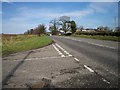
2
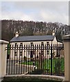
Landscape and Lake
Taken on the Newry Road at the junction with the Demoan road.
Image: © P Flannagan
Taken: 9 Feb 2008
0.13 miles
3
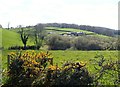
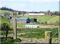
Farmhouse and out-buildings between the Old Road and the Newry Road
Image: © Eric Jones
Taken: 10 Apr 2019
0.22 miles
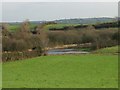
4
View across undulating pasture towards the forests of the Drumbanagher Demesne
Image: © Eric Jones
Taken: 10 Apr 2019
0.22 miles
5
Farm buildings between the Old Road and the A27 (Tandragee Road)
Image: © Eric Jones
Taken: 10 Apr 2019
0.23 miles
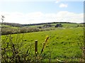
7
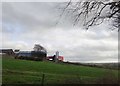
Drumlin top farm buildings East of the A27
Image: © Eric Jones
Taken: 21 Feb 2019
0.24 miles