IMAGES TAKEN NEAR TO
Hillside Crescent, NEWRY, BT35 6SX
Introduction
This page details the photographs taken nearby to Hillside Crescent, BT35 6SX by members of the Geograph project.
The Geograph project started in 2005 with the aim of publishing, organising and preserving representative images for every square kilometre of Great Britain, Ireland and the Isle of Man.

There are currently over 7.5m images from over14,400 individuals and you can help contribute to the project by visiting https://www.geograph.org.uk
Image Map
Images are licensed for reuse under creativecommons.org/licenses/by-sa/2.0
Notes
- Clicking on the map will re-center to the selected point.
- The higher the marker number, the further away the image location is from the centre of the postcode.
Image Listing (82 Images Found)
Images are licensed for reuse under creativecommons.org/licenses/by-sa/2.0
Image
Details
Distance
1
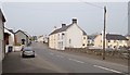
View West along Meeting Street, Poyntzpass
Image: © Eric Jones
Taken: 18 Apr 2019
0.02 miles
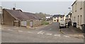
2
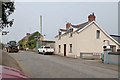
The Western end of Meeting House Road, Poyntzpass
The gate on the right leads to Troughton and Bell Agricultural Machinery Dealers for Tractors and Weidemann Loading Shovels. The tractor on the left is passing Ye Olde Dyke Inn.
Image: © Eric Jones
Taken: 18 Apr 2019
0.03 miles
3
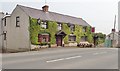
Ye Olde Dyke Inn, Poyntzpass
This inn is located at the western approach to the village. The name Ye Olde Dyke Inn is a reference to the Black Pig Dyke - a linear earthworks which extends through South Armagh to South Down and known by various names including Dane's Cast and the Dorsey. In the past the inn has been known by various names including Monaghan’s, Mrs Mann’s, Kavanagh’s, Owenie’s,
Trainor’s and Doc’s.
http://www.poyntzpass.co.uk/wp-content/uploads/2012/09/A-DROP-OF-THE-HARD-STUFF.pdf
Image: © Eric Jones
Taken: 18 Apr 2019
0.03 miles
4
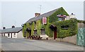
Ye Olde Dyke Inn, Meeting Street, Poyntzpass
The name Ye Olde Dyke Inn is a reference to the Black Pig Dyke - a linear earthworks which extends through South Armagh to South Down and known by various names including Dane's Cast and the Dorsey. In the past the inn has been known by various names including Monaghan’s, Mrs Mann’s, Kavanagh’s, Owenie’s,
Trainor’s and Doc’s.
http://www.poyntzpass.co.uk/wp-content/uploads/2012/09/A-DROP-OF-THE-HARD-STUFF.pdf
Image: © Eric Jones
Taken: 18 Apr 2019
0.03 miles
5
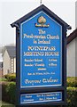
Information Board outside Poyntzpass Presbyterian Church.
Image: © Eric Jones
Taken: 18 Apr 2019
0.04 miles
6
The Presbyterian Meeting House, Poyntzpass
Image: © Eric Jones
Taken: 18 Apr 2019
0.05 miles
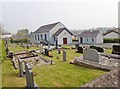
7
The Presbyterian Meeting House, Poyntzpass
Located in Meeting Street, this architecturally plain building, together with a detached schoolroom building, dates back to 1836. Poyntzpass shares a minister with the churches at Cremore and Fourtowns.
Image: © Eric Jones
Taken: 18 Apr 2019
0.05 miles
8
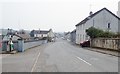
View East along Meeting Street in the direction of The Square at Poyntzpass
The street is named after the Presbyterian Meeting House the graveyard wall of which can be seen on the left.
Image: © Eric Jones
Taken: 18 Apr 2019
0.06 miles
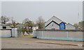
9
Meeting Terrace, off Meeting Street, Poyntzpass
Image: © Eric Jones
Taken: 18 Apr 2019
0.06 miles
10
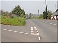
Tannyoky Road departing Poyntzpass
This road links Poyntzpass with the town of Market Hill.
Image: © Eric Jones
Taken: 18 Apr 2019
0.06 miles