IMAGES TAKEN NEAR TO
William Street, NEWRY, BT35 6SS
Introduction
This page details the photographs taken nearby to William Street, BT35 6SS by members of the Geograph project.
The Geograph project started in 2005 with the aim of publishing, organising and preserving representative images for every square kilometre of Great Britain, Ireland and the Isle of Man.

There are currently over 7.5m images from over14,400 individuals and you can help contribute to the project by visiting https://www.geograph.org.uk
Image Map
Images are licensed for reuse under creativecommons.org/licenses/by-sa/2.0
Notes
- Clicking on the map will re-center to the selected point.
- The higher the marker number, the further away the image location is from the centre of the postcode.
Image Listing (107 Images Found)
Images are licensed for reuse under creativecommons.org/licenses/by-sa/2.0
Image
Details
Distance
1
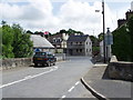
Railway Street, Poyntzpass
Looking towards the Bann Road, Orange Hall on the left.
Image: © HENRY CLARK
Taken: 12 Jul 2009
0.03 miles
2
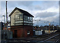
Poyntz Pass Railway Station
Poyntz Pass Station is managed by NI Railways and is located in or near Poyntz Pass (Newry and Mourne).
Image: © sarah gallagher
Taken: 18 Jan 2009
0.05 miles
3
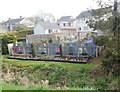
Charming novelty garden backing on to the Newry Canal at Poyntzpass
The houses are in William Street in the County Down - the canal here being the border between Cos Armagh and Down.
Image: © Eric Jones
Taken: 18 Apr 2019
0.05 miles
4
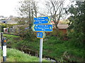
Ulster Way signs on the Newry Canal Towpath at Poyntzpass
Image: © Eric Jones
Taken: 18 Apr 2019
0.05 miles
5
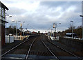
Poyntz Pass Railway Station
Looking down the tracks at Poyntz Pass
Image: © sarah gallagher
Taken: 18 Jan 2009
0.05 miles
6

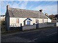
The Poyntzpass Orange Hall
The hall overlooks the Newry Canal at the junction of Railway Street and Bann Road.
Image: © Eric Jones
Taken: 21 Feb 2019
0.05 miles
7

The Newry Canal cycle track heading North from Poyntzpass
This is a section of Sustrans 9.
Image: © Eric Jones
Taken: 21 Feb 2019
0.05 miles
8
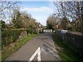
The Newry to Portadown Canal Walkway at Poyntzpass
Image: © P Flannagan
Taken: 9 Feb 2008
0.06 miles
10
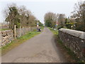
The Towpath Bridge over the Gribben's River at Poyntzpass
Here, the tow path runs North in the direction of Scarva.
Image: © Eric Jones
Taken: 18 Apr 2019
0.06 miles