IMAGES TAKEN NEAR TO
Tyrones Ditches, NEWRY, BT35 6RS
Introduction
This page details the photographs taken nearby to Tyrones Ditches, BT35 6RS by members of the Geograph project.
The Geograph project started in 2005 with the aim of publishing, organising and preserving representative images for every square kilometre of Great Britain, Ireland and the Isle of Man.

There are currently over 7.5m images from over14,400 individuals and you can help contribute to the project by visiting https://www.geograph.org.uk
Image Map
Images are licensed for reuse under creativecommons.org/licenses/by-sa/2.0
Notes
- Clicking on the map will re-center to the selected point.
- The higher the marker number, the further away the image location is from the centre of the postcode.
Image Listing (4 Images Found)
Images are licensed for reuse under creativecommons.org/licenses/by-sa/2.0
Image
Details
Distance
1
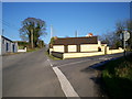
Junction of Tullynacross Road and Demoan Road, Poyntzpass
Image: © P Flannagan
Taken: 12 Feb 2008
0.08 miles
2
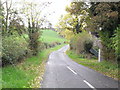
Demoan Road, Corcrum
Townland of Corcrum.
Image: © Dean Molyneaux
Taken: 18 Oct 2009
0.11 miles
3
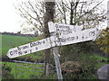
Finger post at Corcrum
Where the Demoan Road crosses the Tullynacross Road near Tyrone's Ditches. They've certainly seen better days - note the elusive 'C' Road designations, which are normally only used internally by local authorities. Townland of Corcrum.
Image: © Dean Molyneaux
Taken: 18 Oct 2009
0.15 miles
4
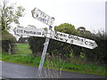
Finger post at Corcrum (2)
Where the Demoan Road crosses the Tullynacross Road near Tyrone's Ditches. They've certainly seen better days - note the elusive 'C' Road designations, which are normally only used internally by local authorities. Townland of Corcrum.
Image: © Dean Molyneaux
Taken: 18 Oct 2009
0.15 miles