IMAGES TAKEN NEAR TO
Carnbane Industrial Estate, NEWRY, BT35 6QQ
Introduction
This page details the photographs taken nearby to Carnbane Industrial Estate, BT35 6QQ by members of the Geograph project.
The Geograph project started in 2005 with the aim of publishing, organising and preserving representative images for every square kilometre of Great Britain, Ireland and the Isle of Man.

There are currently over 7.5m images from over14,400 individuals and you can help contribute to the project by visiting https://www.geograph.org.uk
Image Map
Images are licensed for reuse under creativecommons.org/licenses/by-sa/2.0
Notes
- Clicking on the map will re-center to the selected point.
- The higher the marker number, the further away the image location is from the centre of the postcode.
Image Listing (7 Images Found)
Images are licensed for reuse under creativecommons.org/licenses/by-sa/2.0
Image
Details
Distance
1
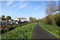
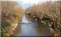
Newry Canal
Looking towards Newry from opposite the Carnbane Industrial Estate.
Image: © Robert Ashby
Taken: 29 Oct 2014
0.17 miles
2
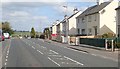
Houses alongside the A27 at Carnbane Gardens
These houses are on the urban fringe of Newry.
Image: © Eric Jones
Taken: 10 Apr 2019
0.19 miles
3
On the Newry Canal
Carnbane Industrial Estate near Newry.
Image: © Robert Ashby
Taken: 29 Oct 2014
0.19 miles
4
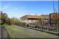
Trevor Warde Groupage Services off the A2 at Carnbane, Newry
This is a haulier company.
Image: © Eric Jones
Taken: 10 Apr 2019
0.20 miles
5

EB Gas Services at the Carnbane Industrial Estate, Newry
Image: © Eric Jones
Taken: 21 Feb 2019
0.22 miles
6
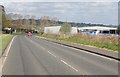
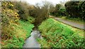
The Newry River
The Newry River (looking upstream) at Carnbane.
Image: © Albert Bridge
Taken: 8 Mar 2008
0.23 miles
7
Disused canal near Newry (2)
The disused Newry canal (looking towards Newry) at Carnbane. Not quite as rural as it seems. There is plethora of warehouses behind the trees on the left.
Image: © Albert Bridge
Taken: 22 Nov 2008
0.25 miles