IMAGES TAKEN NEAR TO
Kidds Road, NEWRY, BT35 6PY
Introduction
This page details the photographs taken nearby to Kidds Road, BT35 6PY by members of the Geograph project.
The Geograph project started in 2005 with the aim of publishing, organising and preserving representative images for every square kilometre of Great Britain, Ireland and the Isle of Man.

There are currently over 7.5m images from over14,400 individuals and you can help contribute to the project by visiting https://www.geograph.org.uk
Image Map
Images are licensed for reuse under creativecommons.org/licenses/by-sa/2.0
Notes
- Clicking on the map will re-center to the selected point.
- The higher the marker number, the further away the image location is from the centre of the postcode.
Image Listing (4 Images Found)
Images are licensed for reuse under creativecommons.org/licenses/by-sa/2.0
Image
Details
Distance
2
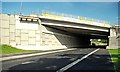
The new Newry bypass (70)
See Image The flyover across the Armagh Road with Belfast to the right. There will not be any access to the bypass here. The junction will be at Carnbane Image Continue to Image
Image: © Albert Bridge
Taken: 30 Jul 2009
0.10 miles
3
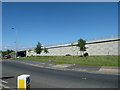
The A1 viaduct from the A28 (Armagh) Road
Image: © Eric Jones
Taken: 3 Jun 2016
0.14 miles
4
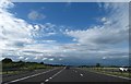
The A1 approaching the turn-off for the A28 (Armagh Road)
Image: © Eric Jones
Taken: 15 Jun 2013
0.19 miles