IMAGES TAKEN NEAR TO
Armagh Road, NEWRY, BT35 6NR
Introduction
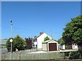
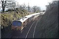
This page details the photographs taken nearby to Armagh Road, BT35 6NR by members of the Geograph project.
The Geograph project started in 2005 with the aim of publishing, organising and preserving representative images for every square kilometre of Great Britain, Ireland and the Isle of Man.

There are currently over 7.5m images from over14,400 individuals and you can help contribute to the project by visiting https://www.geograph.org.uk
Image Map
Images are licensed for reuse under creativecommons.org/licenses/by-sa/2.0
Notes
- Clicking on the map will re-center to the selected point.
- The higher the marker number, the further away the image location is from the centre of the postcode.
Image Listing (3 Images Found)
Images are licensed for reuse under creativecommons.org/licenses/by-sa/2.0
Image
Details
Distance
3
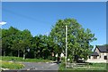
Red, White and Blue painted kerbstones at Mullaghglass
The image taken from the A28 shows the junction of Goragh Road and Latt Crescent in the predominantly loyalist village of Mullaghglass. By contrast, in 2011 91.5% of the population of nearby Newry City had a Catholic Community background.
Image: © Eric Jones
Taken: 3 Jun 2016
0.22 miles