IMAGES TAKEN NEAR TO
Lissummon Church Road, NEWRY, BT35 6FQ
Introduction
This page details the photographs taken nearby to Lissummon Church Road, BT35 6FQ by members of the Geograph project.
The Geograph project started in 2005 with the aim of publishing, organising and preserving representative images for every square kilometre of Great Britain, Ireland and the Isle of Man.

There are currently over 7.5m images from over14,400 individuals and you can help contribute to the project by visiting https://www.geograph.org.uk
Image Map
Images are licensed for reuse under creativecommons.org/licenses/by-sa/2.0
Notes
- Clicking on the map will re-center to the selected point.
- The higher the marker number, the further away the image location is from the centre of the postcode.
Image Listing (3 Images Found)
Images are licensed for reuse under creativecommons.org/licenses/by-sa/2.0
Image
Details
Distance
1
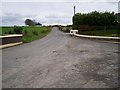
Lissummon Road
Off the Newry to Armagh road.
Image: © P Flannagan
Taken: 26 Apr 2008
0.05 miles
2
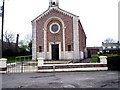
Roman Catholic Church of the Immaculate Conception
Situated at Lissummon southwest of Poyntzpass, the chapel was rebuilt c.1933
Image: © P Flannagan
Taken: 26 Apr 2008
0.06 miles
3
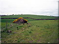
Crankey Townland
Looking west towards the A28 Newry to Armagh road.
Image: © P Flannagan
Taken: 26 Apr 2008
0.12 miles