IMAGES TAKEN NEAR TO
Slieve Gullion Road, NEWRY, BT35 6EW
Introduction
This page details the photographs taken nearby to Slieve Gullion Road, BT35 6EW by members of the Geograph project.
The Geograph project started in 2005 with the aim of publishing, organising and preserving representative images for every square kilometre of Great Britain, Ireland and the Isle of Man.

There are currently over 7.5m images from over14,400 individuals and you can help contribute to the project by visiting https://www.geograph.org.uk
Image Map
Images are licensed for reuse under creativecommons.org/licenses/by-sa/2.0
Notes
- Clicking on the map will re-center to the selected point.
- The higher the marker number, the further away the image location is from the centre of the postcode.
Image Listing (7 Images Found)
Images are licensed for reuse under creativecommons.org/licenses/by-sa/2.0
Image
Details
Distance
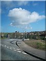
1
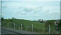
Part of the green belt between inner Newry and the Derrybeg Housing Estate
The church in the background is St Brigid's
Image: © Eric Jones
Taken: 16 May 2014
0.12 miles
2
St Brigid's Catholic Church, Derrybeg
This modern style church was built in 1970.
Image: © Eric Jones
Taken: 30 Apr 2013
0.14 miles
3
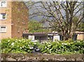
Entrance to the Nurses Home at Daisy Hill Hospital, Newry
Image: © Eric Jones
Taken: 16 May 2012
0.20 miles
4
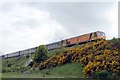
218 on the Wellington Bank
218 on the Wellington Bank approaching Newry Station, which is out of sight to the right of the photo
Image: © Wilson Adams
Taken: 15 May 2004
0.21 miles
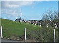
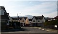
5
Unnamed road leading to the Housing Executive estate of Derrybeg
Image: © Eric Jones
Taken: 30 Apr 2013
0.22 miles
6
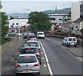
The Camlough Road near Daisy Hill Hospital
The heavy traffic is bound for the city centre.
Image: © Eric Jones
Taken: 19 Jun 2013
0.23 miles
7
Lisdarragh Road
This is another cul-de-sac leading from the A27 (Armagh Road). Camlough Mountain forms the background.
Image: © Eric Jones
Taken: 2 Mar 2011
0.24 miles