IMAGES TAKEN NEAR TO
Erskine Street, NEWRY, BT35 6BX
Introduction
This page details the photographs taken nearby to Erskine Street, BT35 6BX by members of the Geograph project.
The Geograph project started in 2005 with the aim of publishing, organising and preserving representative images for every square kilometre of Great Britain, Ireland and the Isle of Man.

There are currently over 7.5m images from over14,400 individuals and you can help contribute to the project by visiting https://www.geograph.org.uk
Image Map
Images are licensed for reuse under creativecommons.org/licenses/by-sa/2.0
Notes
- Clicking on the map will re-center to the selected point.
- The higher the marker number, the further away the image location is from the centre of the postcode.
Image Listing (349 Images Found)
Images are licensed for reuse under creativecommons.org/licenses/by-sa/2.0
Image
Details
Distance
1
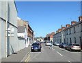
Erskine Street, Newry
This is a side street off the A27.
Image: © Eric Jones
Taken: 3 Jun 2016
0.01 miles
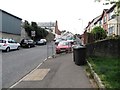
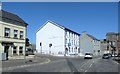
3
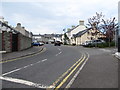
Sinclair Street, Newry
This lies off New Street (A27)
Image: © Eric Jones
Taken: 9 May 2016
0.05 miles
4
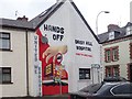
'Hands off Daisy Hill Hospital' mural at the junction of Catherine Street and Canal Street, Newry
Image: © Eric Jones
Taken: 21 Mar 2019
0.05 miles
5
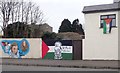
Pro-Palestine murals in Catherine Street, Newry
Image: © Eric Jones
Taken: 21 Mar 2019
0.05 miles
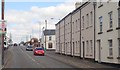
6
Erskine Place, Newry
This street lies between the A27 and the Newry Canal.
Image: © Eric Jones
Taken: 9 May 2016
0.06 miles
7
The north-eastern end of Catherine Street
The modern red brick building is that of Our Lady's Grammar School.
Image: © Eric Jones
Taken: 2 Mar 2011
0.07 miles
8
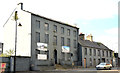
Vacant buildings, Canal Street, Newry (2)
See Image Part of the same site – slightly further to the north west.
Image: © Albert Bridge
Taken: 14 Oct 2013
0.07 miles
9
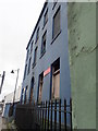
Derelict Georgian Town House at 35 Canal Street, Newry
Image: © Eric Jones
Taken: 21 Mar 2019
0.07 miles
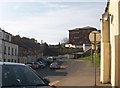
10
View East along New Street, Newry
The image shows the junction of Sinclair Street and New Street and, at the extreme right, the former Clanrye Mill now part of the Fane Valley Co-Op farm foods mill.
Image: © Eric Jones
Taken: 3 Jun 2016
0.08 miles