IMAGES TAKEN NEAR TO
Cecil Street, NEWRY, BT35 6AU
Introduction
This page details the photographs taken nearby to Cecil Street, BT35 6AU by members of the Geograph project.
The Geograph project started in 2005 with the aim of publishing, organising and preserving representative images for every square kilometre of Great Britain, Ireland and the Isle of Man.

There are currently over 7.5m images from over14,400 individuals and you can help contribute to the project by visiting https://www.geograph.org.uk
Image Map
Images are licensed for reuse under creativecommons.org/licenses/by-sa/2.0
Notes
- Clicking on the map will re-center to the selected point.
- The higher the marker number, the further away the image location is from the centre of the postcode.
Image Listing (130 Images Found)
Images are licensed for reuse under creativecommons.org/licenses/by-sa/2.0
Image
Details
Distance
1
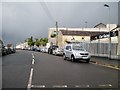
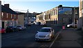
Cul de sac off Edward Street
This street is also known as Edward Street
Image: © Eric Jones
Taken: 16 May 2012
0.06 miles
2
The Newry Campus of the Southern Regional College in Catherine Street
These are the former buildings of Our Lady's Grammar School.
Image: © Eric Jones
Taken: 2 Mar 2011
0.09 miles
3
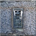
Flush Bracket, Newry
Flush bracket bench mark located on the south eastern tip of a former warehouse (now a carpet shop) on Edward Street in Newry Image
The number on the bracket is OSNIBM 3190.
The mark is 4.19 metres above MSL.
From memory this is the last bracket in the primary line from Belfast to Newry (via Dundonald, Comber and Downpatrick) that began at Image
Image: © Rossographer
Taken: 4 Dec 2013
0.09 miles
4
JT Carpet Warehouse in Upper Edward Street, Newry
Image: © Eric Jones
Taken: 7 Jun 2013
0.09 miles
5
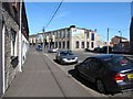
Edward Street, Newry
Edward Street in Newry.
Image: © Rossographer
Taken: 4 Dec 2013
0.09 miles
6
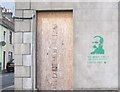
"We defy you! Do your worst!" an ?ir?g? Graffiti in Edward Street
The quotation comes from an article in the "Irish Worker" in 1914 and was addressed to the British administration in Ireland by the author the Scottish-born Irish republican and socialist leader, James Connolly, pictured in the graffiti. Éirígí (meaning "arise") is a republican socialist party active north and south of the border. http://en.wikipedia.org/wiki/%C3%89ir%C3%ADg%C3%AD
Image: © Eric Jones
Taken: 16 May 2012
0.09 miles
7
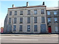
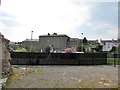
Derelict property in Newry's Zone of Transition
These boarded-up houses are in Corry Square, Edward Street. The site of the demolished building to the left of these houses is used as an Auto-Wash Lot. Such usage is common in Zones of Transition
Image: © Eric Jones
Taken: 7 Jun 2013
0.09 miles
8
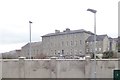
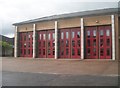
Our Lady's Grammar School, Newry
Opened with just 9 pupils by the Sisters of Mercy in 1887, Our Lady's now has over 850 pupils. Academically, it is a high flying school.
https://en.wikipedia.org/wiki/Our_Lady%27s_Grammar_School
Image: © Eric Jones
Taken: 21 Mar 2019
0.09 miles
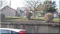
10
The Sisters of Mercy Convent in Catherine Street
Image: © Eric Jones
Taken: 9 May 2016
0.11 miles