IMAGES TAKEN NEAR TO
Carrickacullion Road, NEWRY, BT35 0QY
Introduction
This page details the photographs taken nearby to Carrickacullion Road, BT35 0QY by members of the Geograph project.
The Geograph project started in 2005 with the aim of publishing, organising and preserving representative images for every square kilometre of Great Britain, Ireland and the Isle of Man.

There are currently over 7.5m images from over14,400 individuals and you can help contribute to the project by visiting https://www.geograph.org.uk
Image Map
Images are licensed for reuse under creativecommons.org/licenses/by-sa/2.0
Notes
- Clicking on the map will re-center to the selected point.
- The higher the marker number, the further away the image location is from the centre of the postcode.
Image Listing (7 Images Found)
Images are licensed for reuse under creativecommons.org/licenses/by-sa/2.0
Image
Details
Distance
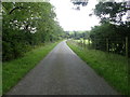
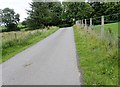
1
The Macullagh Road junction on the Carrickacullion Road
The Carrickacullion Road runs north-westerly to join the A29 south of Newtownhamilton.
Image: © Eric Jones
Taken: 21 Aug 2018
0.17 miles
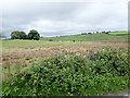
2
Land reclamation on the west side of Carrickacullion Road
Image: © Eric Jones
Taken: 21 Aug 2018
0.19 miles
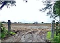
3
Concrete road leading to a farm off the Carrickacullion Road
Image: © Eric Jones
Taken: 21 Aug 2018
0.19 miles
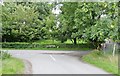
4
View East along Macullagh Road
This section of road is near the junction with Carrickacullion Road.
Image: © Eric Jones
Taken: 21 Aug 2018
0.19 miles
5
Drumlins and wetland hollows on the east side of Carrickacullion Road
Image: © Eric Jones
Taken: 21 Aug 2018
0.20 miles
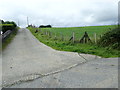
6
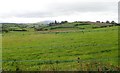
Drumlins south-east of Macullagh Road
In this area arable farming is largely confined to the drier drumlin slope soils. Wetland occupies the interdrumlin hollows.
Image: © Eric Jones
Taken: 21 Aug 2018
0.21 miles