IMAGES TAKEN NEAR TO
Lough Road, NEWRY, BT35 0QR
Introduction
This page details the photographs taken nearby to Lough Road, BT35 0QR by members of the Geograph project.
The Geograph project started in 2005 with the aim of publishing, organising and preserving representative images for every square kilometre of Great Britain, Ireland and the Isle of Man.

There are currently over 7.5m images from over14,400 individuals and you can help contribute to the project by visiting https://www.geograph.org.uk
Image Map
Images are licensed for reuse under creativecommons.org/licenses/by-sa/2.0
Notes
- Clicking on the map will re-center to the selected point.
- The higher the marker number, the further away the image location is from the centre of the postcode.
Image Listing (5 Images Found)
Images are licensed for reuse under creativecommons.org/licenses/by-sa/2.0
Image
Details
Distance
1
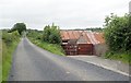
Tin roofed farm buildings on the east side of Lough Road
Image: © Eric Jones
Taken: 21 Aug 2018
0.05 miles
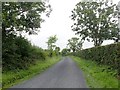
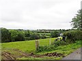
2
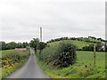
View south along Lough Road
Lough Road runs through a drumlin landscape.
Image: © Eric Jones
Taken: 21 Aug 2018
0.09 miles
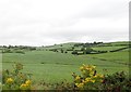
5
View ESE across the incised Camly Valley
Image: © Eric Jones
Taken: 21 Aug 2018
0.18 miles