IMAGES TAKEN NEAR TO
Carrickrovaddy Road, NEWRY, BT35 0QP
Introduction
This page details the photographs taken nearby to Carrickrovaddy Road, BT35 0QP by members of the Geograph project.
The Geograph project started in 2005 with the aim of publishing, organising and preserving representative images for every square kilometre of Great Britain, Ireland and the Isle of Man.

There are currently over 7.5m images from over14,400 individuals and you can help contribute to the project by visiting https://www.geograph.org.uk
Image Map
Images are licensed for reuse under creativecommons.org/licenses/by-sa/2.0
Notes
- Clicking on the map will re-center to the selected point.
- The higher the marker number, the further away the image location is from the centre of the postcode.
Image Listing (18 Images Found)
Images are licensed for reuse under creativecommons.org/licenses/by-sa/2.0
Image
Details
Distance
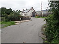
1
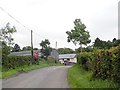
Approaching the Z-bend at the junction of Carrickrovaddy and Drumalt roads
A farmhouse and outbuildings stand at the bend.
Image: © Eric Jones
Taken: 21 Aug 2018
0.00 miles
2
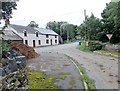
Farmhouse at the junction of Drumalt Road and Carrickrovaddy Road
The road ascending the hill in the background is Lough Road which runs north towards Lough Camly.
Image: © Eric Jones
Taken: 21 Aug 2018
0.01 miles
3
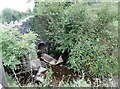
A tributary of the Dorsey emerging from under the Carrockrovaddy Road bridge
Here, the stream is well incised.
Image: © Eric Jones
Taken: 21 Aug 2018
0.01 miles
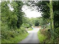
4
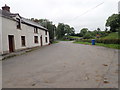
Z-bend on the Carrickrovaddy Road
The other road going to the left in the background is Lough Road.
Image: © Eric Jones
Taken: 21 Aug 2018
0.02 miles
5
The Carrickrovaddy Road Bridge over the Camly River
Image: © Eric Jones
Taken: 21 Aug 2018
0.02 miles
6
Carrickrovaddy Road descending towards the crossroads with Lough Road and Drumalt Road
The crossroads is on a double bend in the Carrickrovaddy Road.
Image: © Eric Jones
Taken: 21 Aug 2018
0.03 miles
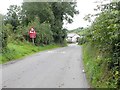
7
Lough Road descending towards the junction with Carrickrovaddy Road
The entrance to Drumalt Road can be seen beyond the blue bin.
Image: © Eric Jones
Taken: 21 Aug 2018
0.03 miles
8
The River Camly above the Carrickrovaddy Road bridge.
The river has its source in Lough Camly.
Image: © Eric Jones
Taken: 21 Aug 2018
0.04 miles
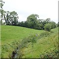
9
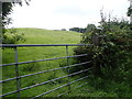
Drumlin grazing land on the eastern side of Drumalt Road
Image: © Eric Jones
Taken: 21 Aug 2018
0.06 miles
10
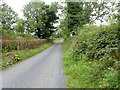
The southern section of Lough Road
The camera points due North.
Image: © Eric Jones
Taken: 21 Aug 2018
0.07 miles