IMAGES TAKEN NEAR TO
Slatequarry Road, NEWRY, BT35 0PX
Introduction
This page details the photographs taken nearby to Slatequarry Road, BT35 0PX by members of the Geograph project.
The Geograph project started in 2005 with the aim of publishing, organising and preserving representative images for every square kilometre of Great Britain, Ireland and the Isle of Man.

There are currently over 7.5m images from over14,400 individuals and you can help contribute to the project by visiting https://www.geograph.org.uk
Image Map
Images are licensed for reuse under creativecommons.org/licenses/by-sa/2.0
Notes
- Clicking on the map will re-center to the selected point.
- The higher the marker number, the further away the image location is from the centre of the postcode.
Image Listing (12 Images Found)
Images are licensed for reuse under creativecommons.org/licenses/by-sa/2.0
Image
Details
Distance
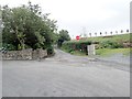
1
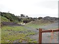
Disused slate quarry off the Drumalt Road above Cullyhanna
Slate was quarried from the Lower Palaeozoic rocks in parts of Cos Armagh and Down. Most of the quarry enterprises were small and short lived. The site is now used as a source of quarry rubble.
Image: © Eric Jones
Taken: 21 Aug 2018
0.05 miles
2
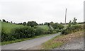
Drumalt Road ascending north-eastwards to the junction with Slatequarry Road
Image: © Eric Jones
Taken: 21 Aug 2018
0.06 miles
3
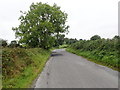
Drumalt Road ascending towards the junction with Slatequarry Road
Image: © Eric Jones
Taken: 21 Aug 2018
0.12 miles
4
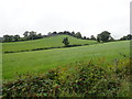
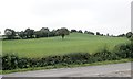
View north-westwards towards Cooey Hill
The image was taken on the Drumalt Road.
Image: © Eric Jones
Taken: 21 Aug 2018
0.14 miles
6
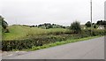
Drumlins on the north side of Drumalt Road
Image: © Eric Jones
Taken: 21 Aug 2018
0.16 miles
7
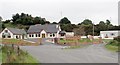
Sweet Dreamzzz Irish hand made Beds
This outlet is located on Drumalt Road, Cullyhanna.
Image: © Eric Jones
Taken: 21 Aug 2018
0.17 miles
8
The continuation of Drumalt Road
Drumalt Road continues eastwards (and then southwards) as a narrow lane. Here, the main road swings left and becomes Slatequarry Road.
Image: © Eric Jones
Taken: 21 Aug 2018
0.17 miles
9
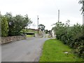
Where Slatequarry Road becomes Drumalt Road
Slatequarry Road ends at the crossroads.
Image: © Eric Jones
Taken: 21 Aug 2018
0.17 miles
10
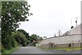
The Drumalt Road/Slatequarry Road junction
Drumalt Road continues on straight uphill as a narrow lane. Some comedian has reversed the "Stop" sign.
Image: © Eric Jones
Taken: 21 Aug 2018
0.19 miles