1
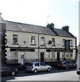
Karakachana Bulgarian Supermarket, Dundalk Street, Newtownhamilton
This store was previously a Day Today Convenience store.
Image: © Eric Jones
Taken: 8 Aug 2019
0.01 miles
2
Karakachana Bulgarian Supermarket, Newtownhamilton
This is located in Dundalk Street.
Image: © Eric Jones
Taken: 8 Aug 2019
0.01 miles
3
View south along Dundalk Street, Newtownhamilton
Image: © Eric Jones
Taken: 3 Jun 2016
0.02 miles
4
South Side Snax, Newtownhamilton
This cafe is located towards the southern end of Dundalk Street.
Image: © Eric Jones
Taken: 8 Aug 2019
0.03 miles
5
The Central Bar, 12 Dundalk Street, Newtownhamilton
The image was taken from the entrance to Castleblayney Road.
Image: © Eric Jones
Taken: 3 Jun 2016
0.04 miles
6
The disused Horseshoe Cafe, Newtownhamilton
This located at the back of the defunct Central Bar.
Image: © Eric Jones
Taken: 8 Aug 2019
0.05 miles
7
The junction of Castleblayney Street and Dundalk Street, Newtownhamilton
Image: © Eric Jones
Taken: 3 Jun 2016
0.05 miles
8
The rear of Armagh Street from the entrance to the Dungormley Estate
Beyond, the tall PSNI telecommunications is a reminder that the village is situated in a remote upland area of South Armagh with a troubled past.
Image: © Eric Jones
Taken: 3 Jun 2016
0.06 miles
9
The derelict Townsend National School at Newtownhamilton
This old school building dates back to the nineteenth century. This would have been a Protestant ethos school.
Image: © Eric Jones
Taken: 3 Jun 2016
0.07 miles
10
Religious and political messages in Castleblayney Street, Newtownhamilton
Monaghan Road, extending westwards from Castleblayney Street winds its way through an area reaching to and beyond the Border inhabited by Presbyterian farming folk whose ancestors were planted in the area in the 17thC. The political poster features Diane Dodds of the DUP, one of the three sitting MEPs for Northern Ireland.
Image: © Eric Jones
Taken: 7 Jun 2019
0.07 miles


