IMAGES TAKEN NEAR TO
School Meadows, NEWRY, BT35 0NG
Introduction
This page details the photographs taken nearby to School Meadows, BT35 0NG by members of the Geograph project.
The Geograph project started in 2005 with the aim of publishing, organising and preserving representative images for every square kilometre of Great Britain, Ireland and the Isle of Man.

There are currently over 7.5m images from over14,400 individuals and you can help contribute to the project by visiting https://www.geograph.org.uk
Image Map
Images are licensed for reuse under creativecommons.org/licenses/by-sa/2.0
Notes
- Clicking on the map will re-center to the selected point.
- The higher the marker number, the further away the image location is from the centre of the postcode.
Image Listing (7 Images Found)
Images are licensed for reuse under creativecommons.org/licenses/by-sa/2.0
Image
Details
Distance
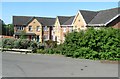
1
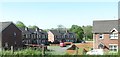
The Meadowvale Estate, Newtownhamilton
This new estate is located on the north-western outskirts of Newtownhamilton.
Image: © Eric Jones
Taken: 3 Jun 2016
0.13 miles
2
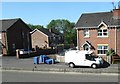
Blue Bin day at Meadowvale, Newtownhamilton
Image: © Eric Jones
Taken: 3 Jun 2016
0.16 miles
3
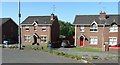
Modern housing in Meadowvale, Newtownhamilton
These face on to the A29.
Image: © Eric Jones
Taken: 3 Jun 2016
0.19 miles
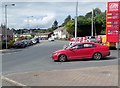
5
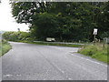
Junction of Armagh/Keady Road outside Newtownhamilton
Main Armagh to Newtownhamilton Road at the junction with the Keady Road looking towards Newtownhamilton.
Image: © Terry Stewart
Taken: 6 Sep 2007
0.23 miles
6
Houses in Pound Court, Newtownhamilton
Here, they are viewed from the A29.
Image: © Eric Jones
Taken: 3 Jun 2016
0.24 miles
7
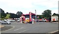
A29 Service Station, Newtownhamilton
This service station is located on Armagh Street
Image: © Eric Jones
Taken: 8 Aug 2019
0.24 miles