IMAGES TAKEN NEAR TO
Lake Road, NEWRY, BT35 0LR
Introduction
This page details the photographs taken nearby to Lake Road, BT35 0LR by members of the Geograph project.
The Geograph project started in 2005 with the aim of publishing, organising and preserving representative images for every square kilometre of Great Britain, Ireland and the Isle of Man.

There are currently over 7.5m images from over14,400 individuals and you can help contribute to the project by visiting https://www.geograph.org.uk
Image Map
Images are licensed for reuse under creativecommons.org/licenses/by-sa/2.0
Notes
- Clicking on the map will re-center to the selected point.
- The higher the marker number, the further away the image location is from the centre of the postcode.
Image Listing (4 Images Found)
Images are licensed for reuse under creativecommons.org/licenses/by-sa/2.0
Image
Details
Distance
1
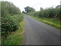
View SSE along Lake Road, Cullyhanna
Lake road joins Sheetrim Road with the B135 (Cloghue Road).
Image: © Eric Jones
Taken: 28 Aug 2019
0.04 miles
2
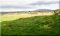
Wooded wetland south of Cullyhanna Lough
The mountain in the background is Slieve Gullion.
Image: © Eric Jones
Taken: 28 Aug 2019
0.10 miles
3
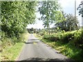
Field lane entrance on the west side of Lake Road
Image: © Eric Jones
Taken: 28 Aug 2019
0.18 miles
4
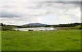
Cullyhanna Lough viewed from the Lake Road
The distinctive outline of Slieve Gullion forms the background.
Image: © Eric Jones
Taken: 28 Aug 2019
0.24 miles