IMAGES TAKEN NEAR TO
Armagh Road, NEWRY, BT35 0EY
Introduction
This page details the photographs taken nearby to Armagh Road, BT35 0EY by members of the Geograph project.
The Geograph project started in 2005 with the aim of publishing, organising and preserving representative images for every square kilometre of Great Britain, Ireland and the Isle of Man.

There are currently over 7.5m images from over14,400 individuals and you can help contribute to the project by visiting https://www.geograph.org.uk
Image Map
Images are licensed for reuse under creativecommons.org/licenses/by-sa/2.0
Notes
- Clicking on the map will re-center to the selected point.
- The higher the marker number, the further away the image location is from the centre of the postcode.
Image Listing (5 Images Found)
Images are licensed for reuse under creativecommons.org/licenses/by-sa/2.0
Image
Details
Distance
1
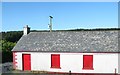
Cladybeg Orange Hall
Cladybeg Orange Hall which dates from 1910 is the home of LOL 305, the "Cladybeg Faith Defenders". In 1997 the hall was burnt down in an arson attack but was later rebuilt and re-roofed. The Fews Forest forms the background.
Image: © Eric Jones
Taken: 3 Jun 2016
0.01 miles
2
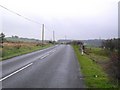
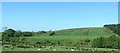
Armagh Road at Clady Beg
A sparsely populated area - two miles north of Newtownhamilton in the townland of Clady Beg.
Image: © Dean Molyneaux
Taken: 18 Oct 2009
0.02 miles
3
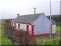
Cladybeg Orange Hall
On the Armagh Road outside Newtownhamilton. It has been attacked in the past. In the townland of Clady Beg.
Image: © Dean Molyneaux
Taken: 18 Oct 2009
0.05 miles
4
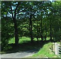
Forestry lane leading to the western section of the Fews Forest
The image was taken from the southern section of the B31 known as the Antrim Road.
Image: © Eric Jones
Taken: 3 Jun 2016
0.11 miles
5
Clady Beg River, an incised tributary of the White Water
The image was taken from the B31 just south of Cladybeg Orange Hall. The woodland on the right is part of the Fews Forest.
Image: © Eric Jones
Taken: 3 Jun 2016
0.24 miles