IMAGES TAKEN NEAR TO
Keady Road, NEWRY, BT35 0ET
Introduction
This page details the photographs taken nearby to Keady Road, BT35 0ET by members of the Geograph project.
The Geograph project started in 2005 with the aim of publishing, organising and preserving representative images for every square kilometre of Great Britain, Ireland and the Isle of Man.

There are currently over 7.5m images from over14,400 individuals and you can help contribute to the project by visiting https://www.geograph.org.uk
Image Map
Images are licensed for reuse under creativecommons.org/licenses/by-sa/2.0
Notes
- Clicking on the map will re-center to the selected point.
- The higher the marker number, the further away the image location is from the centre of the postcode.
Image Listing (1 Images Found)
Images are licensed for reuse under creativecommons.org/licenses/by-sa/2.0
Image
Details
Distance
1
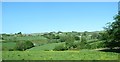
The confluence of the Clady Beg River with the White Water north-west of Newtownhamilton
South of Newtownhamilton the White Water takes the successive names of Tullyvallen River, Cullyhanna River, Creggan River, and (once in the Republic) Castletown River. It discharges into the Irish Sea at Dundalk.
Image: © Eric Jones
Taken: 3 Jun 2016
0.17 miles