IMAGES TAKEN NEAR TO
Dairy Lane, NEWRY, BT35 0AY
Introduction
This page details the photographs taken nearby to Dairy Lane, BT35 0AY by members of the Geograph project.
The Geograph project started in 2005 with the aim of publishing, organising and preserving representative images for every square kilometre of Great Britain, Ireland and the Isle of Man.

There are currently over 7.5m images from over14,400 individuals and you can help contribute to the project by visiting https://www.geograph.org.uk
Image Map
Images are licensed for reuse under creativecommons.org/licenses/by-sa/2.0
Notes
- Clicking on the map will re-center to the selected point.
- The higher the marker number, the further away the image location is from the centre of the postcode.
Image Listing (10 Images Found)
Images are licensed for reuse under creativecommons.org/licenses/by-sa/2.0
Image
Details
Distance
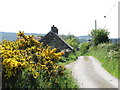
4
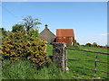
Homestead with a red tin shed on Dairy Lane, Ballymoyer TD
Image: © Eric Jones
Taken: 3 Jun 2016
0.08 miles
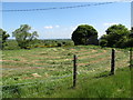
6
Reedy land near the junction of Coiners Lane and Dairy Lane
This is Grade IV agricultural land.
Image: © Eric Jones
Taken: 3 Jun 2016
0.15 miles
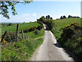
7
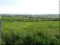
Farmland between Dairy Lane and Lower Aghincurk Road
This is a sparsely populated area with a pastoral economy.
Image: © Eric Jones
Taken: 3 Jun 2016
0.17 miles
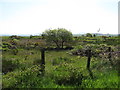
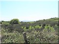
8
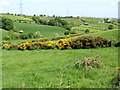
Valley below Dairy Lane
The North-South Interconnector runs along the eastern side of the valley.
Image: © Eric Jones
Taken: 3 Jun 2016
0.18 miles
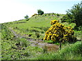
9
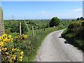
Descending Dairy Lane
The North-south Interconnector can be seen on the skyline left.
Image: © Eric Jones
Taken: 3 Jun 2016
0.20 miles