IMAGES TAKEN NEAR TO
Clady Road, NEWRY, BT35 0AU
Introduction
This page details the photographs taken nearby to Clady Road, BT35 0AU by members of the Geograph project.
The Geograph project started in 2005 with the aim of publishing, organising and preserving representative images for every square kilometre of Great Britain, Ireland and the Isle of Man.

There are currently over 7.5m images from over14,400 individuals and you can help contribute to the project by visiting https://www.geograph.org.uk
Image Map
Images are licensed for reuse under creativecommons.org/licenses/by-sa/2.0
Notes
- Clicking on the map will re-center to the selected point.
- The higher the marker number, the further away the image location is from the centre of the postcode.
Image Listing (2 Images Found)
Images are licensed for reuse under creativecommons.org/licenses/by-sa/2.0
Image
Details
Distance
1
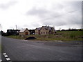
Modern House, Clady Road, Markethill
An increasing sight in rural areas is the construction of large modern houses on spectacular sites, with panoramic views across the "rolling landscape" of Ulster.
Image: © P Flannagan
Taken: 18 Mar 2008
0.10 miles
2
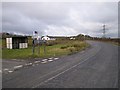
Junction of Aghinturk and Clady Roads, Markethill
Image: © P Flannagan
Taken: 18 Mar 2008
0.11 miles