IMAGES TAKEN NEAR TO
Lower Aghincurk Road, NEWRY, BT35 0AS
Introduction
This page details the photographs taken nearby to Lower Aghincurk Road, BT35 0AS by members of the Geograph project.
The Geograph project started in 2005 with the aim of publishing, organising and preserving representative images for every square kilometre of Great Britain, Ireland and the Isle of Man.

There are currently over 7.5m images from over14,400 individuals and you can help contribute to the project by visiting https://www.geograph.org.uk
Image Map
Images are licensed for reuse under creativecommons.org/licenses/by-sa/2.0
Notes
- Clicking on the map will re-center to the selected point.
- The higher the marker number, the further away the image location is from the centre of the postcode.
Image Listing (3 Images Found)
Images are licensed for reuse under creativecommons.org/licenses/by-sa/2.0
Image
Details
Distance
1
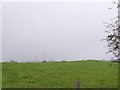
Aghincurk Townland
Off the Lower Aghincurk Road north of Ballymoyer.
Image: © Dean Molyneaux
Taken: 13 Oct 2009
0.08 miles
2
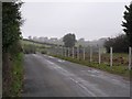
Lower Aghincurk Road, Ballymoyer
Townland of Aghincurk.
Image: © Dean Molyneaux
Taken: 13 Oct 2009
0.09 miles
3
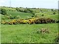
Valley below Dairy Lane
The North-South Interconnector runs along the eastern side of the valley.
Image: © Eric Jones
Taken: 3 Jun 2016
0.24 miles