IMAGES TAKEN NEAR TO
The Square, NEWRY, BT35 0AA
Introduction
This page details the photographs taken nearby to The Square, BT35 0AA by members of the Geograph project.
The Geograph project started in 2005 with the aim of publishing, organising and preserving representative images for every square kilometre of Great Britain, Ireland and the Isle of Man.

There are currently over 7.5m images from over14,400 individuals and you can help contribute to the project by visiting https://www.geograph.org.uk
Image Map
Images are licensed for reuse under creativecommons.org/licenses/by-sa/2.0
Notes
- Clicking on the map will re-center to the selected point.
- The higher the marker number, the further away the image location is from the centre of the postcode.
Image Listing (78 Images Found)
Images are licensed for reuse under creativecommons.org/licenses/by-sa/2.0
Image
Details
Distance
1
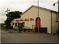
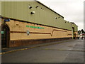
Newtownhamilton Community Centre
At 15 The Square, Newtownhamilton.
Image: © Dean Molyneaux
Taken: 14 Aug 2009
0.01 miles
2
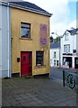
The disused Coffee on the Corner Cafe, The Square, Newtownhamilton
Image: © Eric Jones
Taken: 8 Aug 2019
0.01 miles
3
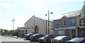
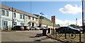
Newtownhamilton Community Centre and Cumiskey Electrics at The Square
These face the PSNI Barracks across the village square.
Image: © Eric Jones
Taken: 3 Jun 2016
0.02 miles
4
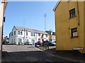
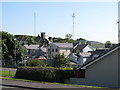
The Square, Newtownhamilton, viewed from Dundalk Street
The three sun-lit premises on the north side of The Square are the Newtownhamilton Credit Union, Mr Buzby's, and the formidable Newtownhamilton PSNI barracks. The Credit Union building was formerly occupied by the Ulster Bank.
Image: © Eric Jones
Taken: 3 Jun 2016
0.02 miles
5
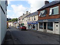
Buildings in the Newry Street Square, Newtownhamilton
The three buildings are the Newtownhamilton Credit Union, previously occupied by the Ulster Bank, Mr Buzby's Cafe and the steel-clad PSNI Barracks.
Image: © Eric Jones
Taken: 7 Jun 2019
0.02 miles
6
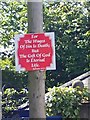
Warning for the citizens of Newtownhamilton
These religious posters, reminiscent of the US Deep South, are a common sight in the religious fault zones of Northern Ireland. They are usually posted by members of Evangelical movements.
Image: © Eric Jones
Taken: 7 Jun 2019
0.02 miles
7
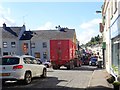
Heavy traffic in Dundalk Street (A29), Newtownhamilton
Image: © Eric Jones
Taken: 7 Jun 2019
0.02 miles
9
The rear of Armagh Street from the entrance to the Dungormley Estate
Beyond, the tall PSNI telecommunications is a reminder that the village is situated in a remote upland area of South Armagh with a troubled past.
Image: © Eric Jones
Taken: 3 Jun 2016
0.02 miles
10
Newtownhamilton Police Station
P.S.N.I. Barracks at the Square, Newtownhamilton. The 'Bandit Country' police stations are always the most heavily fortified, as can be seen here.
Image: © Dean Molyneaux
Taken: 14 Aug 2009
0.03 miles