IMAGES TAKEN NEAR TO
Kilkeel Road, NEWRY, BT34 5XZ
Introduction
This page details the photographs taken nearby to Kilkeel Road, BT34 5XZ by members of the Geograph project.
The Geograph project started in 2005 with the aim of publishing, organising and preserving representative images for every square kilometre of Great Britain, Ireland and the Isle of Man.

There are currently over 7.5m images from over14,400 individuals and you can help contribute to the project by visiting https://www.geograph.org.uk
Image Map
Images are licensed for reuse under creativecommons.org/licenses/by-sa/2.0
Notes
- Clicking on the map will re-center to the selected point.
- The higher the marker number, the further away the image location is from the centre of the postcode.
Image Listing (16 Images Found)
Images are licensed for reuse under creativecommons.org/licenses/by-sa/2.0
Image
Details
Distance
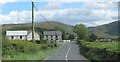
1
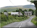
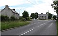
Farmsteads on the north side of the Kilkeel Road (B27)
Image: © Eric Jones
Taken: 15 May 2014
0.04 miles
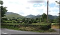
2
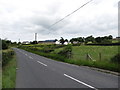
Approaching the junction of the B27 (Kilkeel Road) and the B180 road to Newcastle
Image: © Eric Jones
Taken: 15 May 2014
0.10 miles
3
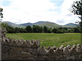
Fields running down to the River Bann
The Mournes form the background.
Image: © Eric Jones
Taken: 15 May 2014
0.11 miles
4
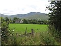
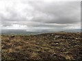
View across the flood plain of the River Bann towards the Hen and Cock mountains
Image: © Eric Jones
Taken: 15 May 2014
0.12 miles
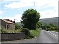
5
The B27 at its junction with the B180
The B27 runs between Hilltown and Kilkeel through the Mourne Mountains. The B180 Bryansford Road runs alongside the northern flank of the Mournes.
Image: © Eric Jones
Taken: 15 May 2014
0.13 miles
6
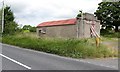
Disused garage and car wash on the Kilkeel Road
Image: © Eric Jones
Taken: 15 May 2014
0.15 miles
7
View east along the B27 (Kilkeel Road)
The building on the left is a disused store and car wash.
Image: © Eric Jones
Taken: 15 May 2014
0.16 miles
8
A shower approaches Cock Mountain
This was a rogue shower on an otherwise dry day.
Image: © Eric Jones
Taken: 31 Aug 2016
0.17 miles
9
The B27 (Kilkeel Road) near its junction with the B180 (Bryansford Road)
The western Mournes form the background.
Image: © Eric Jones
Taken: 30 Jun 2011
0.17 miles
10
View across the flood plain of the River Bann upstream of Hilltown
The "Birds" summits of the Western Mourne - Hen, Cock, Pigeon and Eagle - are visible in the background.
Image: © Eric Jones
Taken: 15 May 2014
0.19 miles