IMAGES TAKEN NEAR TO
New Line, NEWRY, BT34 5XT
Introduction
This page details the photographs taken nearby to New Line, BT34 5XT by members of the Geograph project.
The Geograph project started in 2005 with the aim of publishing, organising and preserving representative images for every square kilometre of Great Britain, Ireland and the Isle of Man.

There are currently over 7.5m images from over14,400 individuals and you can help contribute to the project by visiting https://www.geograph.org.uk
Image Map
Images are licensed for reuse under creativecommons.org/licenses/by-sa/2.0
Notes
- Clicking on the map will re-center to the selected point.
- The higher the marker number, the further away the image location is from the centre of the postcode.
Image Listing (6 Images Found)
Images are licensed for reuse under creativecommons.org/licenses/by-sa/2.0
Image
Details
Distance
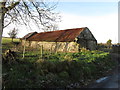
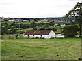
2
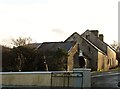
Derelict farm buildings on New Line road
Image: © Eric Jones
Taken: 11 Dec 2012
0.15 miles
3
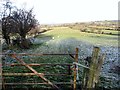
Farm land below the New Line road
This is an area of marginal pastoral agriculture.
Image: © Eric Jones
Taken: 11 Dec 2012
0.16 miles
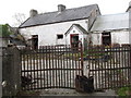
4
Disused traditional cottage at Leitrim
This has now been converted to other purposes.
Image: © Eric Jones
Taken: 8 Aug 2015
0.19 miles
5
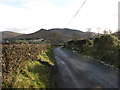
View eastwards along the New Line road
The Hen and Cock Mountains dominate the background.
Image: © Eric Jones
Taken: 11 Dec 2012
0.23 miles