IMAGES TAKEN NEAR TO
Clonduff Road, NEWRY, BT34 5XF
Introduction
This page details the photographs taken nearby to Clonduff Road, BT34 5XF by members of the Geograph project.
The Geograph project started in 2005 with the aim of publishing, organising and preserving representative images for every square kilometre of Great Britain, Ireland and the Isle of Man.

There are currently over 7.5m images from over14,400 individuals and you can help contribute to the project by visiting https://www.geograph.org.uk
Image Map
Images are licensed for reuse under creativecommons.org/licenses/by-sa/2.0
Notes
- Clicking on the map will re-center to the selected point.
- The higher the marker number, the further away the image location is from the centre of the postcode.
Image Listing (7 Images Found)
Images are licensed for reuse under creativecommons.org/licenses/by-sa/2.0
Image
Details
Distance
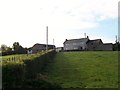
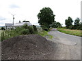
2
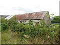
Traditional tin-roofed farm building off the Clonduff Road
Image: © Eric Jones
Taken: 15 May 2014
0.05 miles
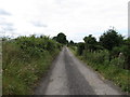
3
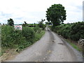
Access lane leading northeastwards from the junction with Clonnduff Road
Image: © Eric Jones
Taken: 15 May 2014
0.07 miles
4
View WSW in the direction of the junction with Clonduff Road
Image: © Eric Jones
Taken: 15 May 2014
0.08 miles
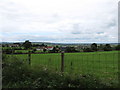
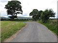
5
View WSW along the middle section of Clonduff Road
Image: © Eric Jones
Taken: 15 May 2014
0.12 miles
6
Track junction at a bend in the Clonduff Road
While the road bends to the left to begin its descent down to the B37 (Kilkeel Road) a track continues straight on towards Hilltown.
Image: © Eric Jones
Taken: 15 May 2014
0.14 miles