IMAGES TAKEN NEAR TO
Lisnamulligan Road, NEWRY, BT34 5XA
Introduction
This page details the photographs taken nearby to Lisnamulligan Road, BT34 5XA by members of the Geograph project.
The Geograph project started in 2005 with the aim of publishing, organising and preserving representative images for every square kilometre of Great Britain, Ireland and the Isle of Man.

There are currently over 7.5m images from over14,400 individuals and you can help contribute to the project by visiting https://www.geograph.org.uk
Image Map
Images are licensed for reuse under creativecommons.org/licenses/by-sa/2.0
Notes
- Clicking on the map will re-center to the selected point.
- The higher the marker number, the further away the image location is from the centre of the postcode.
Image Listing (8 Images Found)
Images are licensed for reuse under creativecommons.org/licenses/by-sa/2.0
Image
Details
Distance
2
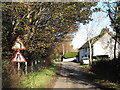
Lisnamulligan Road at the eastern approach to Lisnamulligan Bridge
Image: © Eric Jones
Taken: 5 Nov 2011
0.02 miles
3
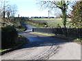
The Lisnamulligan Road bridge over the River Bann
Image: © Eric Jones
Taken: 5 Nov 2011
0.03 miles
4
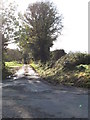
The narrow, and partially flooded, northern end of Mill Road
Image: © Eric Jones
Taken: 5 Nov 2011
0.03 miles
5
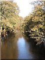
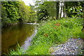
The River Bann from the Lisnamulligan Bridge
This is the view north.
Image: © Eric Jones
Taken: 5 Nov 2011
0.06 miles
6
Derelict cottage above Lisnamulligan Bridge
Image: © Eric Jones
Taken: 5 Nov 2011
0.10 miles
7
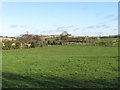
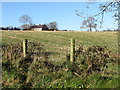
Farmland north of Lisnamulligan Road
This is part of the flood plain of the Upper Bann.
Image: © Eric Jones
Taken: 5 Nov 2011
0.13 miles
8
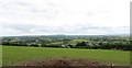
The Bann Valley north of Hilltown
The image is taken from above the B8 (Castlewellan Road),
Image: © Eric Jones
Taken: 15 May 2014
0.14 miles