IMAGES TAKEN NEAR TO
Glenveagh, NEWRY, BT34 5US
Introduction
This page details the photographs taken nearby to Glenveagh, BT34 5US by members of the Geograph project.
The Geograph project started in 2005 with the aim of publishing, organising and preserving representative images for every square kilometre of Great Britain, Ireland and the Isle of Man.

There are currently over 7.5m images from over14,400 individuals and you can help contribute to the project by visiting https://www.geograph.org.uk
Image Map
Images are licensed for reuse under creativecommons.org/licenses/by-sa/2.0
Notes
- Clicking on the map will re-center to the selected point.
- The higher the marker number, the further away the image location is from the centre of the postcode.
Image Listing (152 Images Found)
Images are licensed for reuse under creativecommons.org/licenses/by-sa/2.0
Image
Details
Distance
1
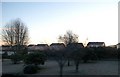
Houses in Glenveagh from the Rathfriland Road
Image: © Eric Jones
Taken: 20 Feb 2010
0.01 miles
2
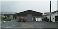
Industrial units on the Rathfriland Road
Image: © Eric Jones
Taken: 10 Jul 2010
0.09 miles
4
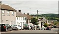
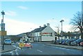
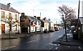
Main Street, Hilltown
The view eastwards along the main street, in the direction of Castlewellan and Kilkeel, to where the Co Down drumlins end and the Mournes begin.
Image: © Albert Bridge
Taken: 11 Aug 2009
0.11 miles
5
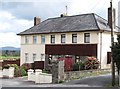
A pair of semi detached houses in Rathfriland Road, Hilltown
The architecture however is unmistakable being the work of the Englishman T.F.O. Rippingham who was commissioned to design police stations for the RUC in the 1920s and 1930s.
http://en.wikipedia.org/wiki/T._F._O._Rippingham
Image: © Eric Jones
Taken: 14 Apr 2012
0.11 miles
6
Road Temporarily Closed - the Upper Section of Main Street, Hilltown
The road is closed for resurfacing.
Image: © Eric Jones
Taken: 2 Apr 2011
0.11 miles
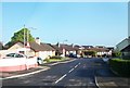
7
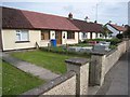
Bungalows on the Rathfriland Road, Hilltown
Image: © Oliver Dixon
Taken: 12 May 2007
0.11 miles
8
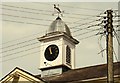
Clock, Hilltown
The “Hill” in Hilltown is not topographical but the “Hills” of Hillsborough Image The town was established in 1766 to serve as a centre for the expected growth in the linen industry in the surrounding area. In practice that industry never reached the town but the market house and the adjoining “Downshire Arms”, both of which seem to date from 1824, have survived. The clock (not working) is on the restored market house.
Image: © Albert Bridge
Taken: 11 Aug 2009
0.11 miles
9
Houses and shops on Castlewellan Road, Hilltown
Image: © Eric Jones
Taken: 11 Dec 2012
0.11 miles
10
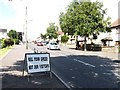
Safety notice on Castlewellan Road, Hilltown
These signs have been erected on all roads leading to the town by the Boley Fair organisers.
Image: © Eric Jones
Taken: 15 Jul 2014
0.11 miles