IMAGES TAKEN NEAR TO
Main Street, NEWRY, BT34 5UJ
Introduction
This page details the photographs taken nearby to Main Street, BT34 5UJ by members of the Geograph project.
The Geograph project started in 2005 with the aim of publishing, organising and preserving representative images for every square kilometre of Great Britain, Ireland and the Isle of Man.

There are currently over 7.5m images from over14,400 individuals and you can help contribute to the project by visiting https://www.geograph.org.uk
Image Map
Images are licensed for reuse under creativecommons.org/licenses/by-sa/2.0
Notes
- Clicking on the map will re-center to the selected point.
- The higher the marker number, the further away the image location is from the centre of the postcode.
Image Listing (151 Images Found)
Images are licensed for reuse under creativecommons.org/licenses/by-sa/2.0
Image
Details
Distance
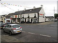
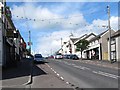
1
View east along Main Street, Hilltown
Hilltown, in contrast to Rathfriland, is a Catholic and Nationalist town. In 2001, 97% of the population were from this background. This compared with a Protestant majority of 64% at nearby Rathfriland.
Image: © Eric Jones
Taken: 20 Feb 2010
0.02 miles
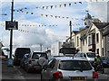
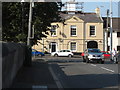
2
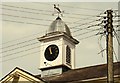
Clock, Hilltown
The “Hill” in Hilltown is not topographical but the “Hills” of Hillsborough Image The town was established in 1766 to serve as a centre for the expected growth in the linen industry in the surrounding area. In practice that industry never reached the town but the market house and the adjoining “Downshire Arms”, both of which seem to date from 1824, have survived. The clock (not working) is on the restored market house.
Image: © Albert Bridge
Taken: 11 Aug 2009
0.02 miles
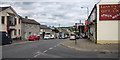
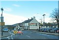
3
The B8 (Castlewellan Road) ascending towards The Square at Hilltown
Image: © Eric Jones
Taken: 15 Jul 2014
0.02 miles
4
Traffic tail back leading to The Square at Hilltown
Image: © Eric Jones
Taken: 15 Jul 2014
0.02 miles
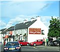
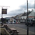
5
Main Street, Hilltown
The main street (B8) running through the village of Hilltown.
Image: © Rossographer
Taken: 3 Jul 2017
0.02 miles
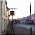
7
The junction of Rostrevor Road and Main Street, Hilltown
Image: © Eric Jones
Taken: 14 Sep 2016
0.03 miles
8
Road Temporarily Closed - the Upper Section of Main Street, Hilltown
The road is closed for resurfacing.
Image: © Eric Jones
Taken: 2 Apr 2011
0.03 miles