IMAGES TAKEN NEAR TO
St. Patricks Park, NEWRY, BT34 5UA

Introduction

This page details the photographs taken nearby to St. Patricks Park, BT34 5UA by members of the Geograph project.

The Geograph project started in 2005 with the aim of publishing, organising and preserving representative images for every square kilometre of Great Britain, Ireland and the Isle of Man.

There are currently over 7.5m images from over14,400 individuals and you can help contribute to the project by visiting https://www.geograph.org.uk

Image Map


Images are licensed for reuse under creativecommons.org/licenses/by-sa/2.0
Notes
  • Clicking on the map will re-center to the selected point.
  • The higher the marker number, the further away the image location is from the centre of the postcode.

Image Listing (142 Images Found)

Images are licensed for reuse under creativecommons.org/licenses/by-sa/2.0
  • ...
Image
Details
Distance
1
The INF Hall on Rostrevor Road, Hilltown
The INF (Irish National Foresters) is a benevolent society. http://en.wikipedia.org/wiki/Irish_National_Foresters
Image: © Eric Jones Taken: 11 Dec 2012
0.07 miles
2
The Ferns Estate off Rostrevor Road, Hilltown
Image: © Eric Jones Taken: 11 Dec 2012
0.07 miles
3
The John O'Neill Lodge of the Irish National Foresters at Hilltown
The INF (Irish National Foresters) is a benevolent society. http://en.wikipedia.org/wiki/Irish_National_Foresters
Image: © Eric Jones Taken: 12 Mar 2013
0.08 miles
4
Irish National Foresters Hall at Hilltown
This is located in Rostrevor Road.
Image: © Eric Jones Taken: 9 Sep 2011
0.08 miles
5
St John's Church of Ireland, Hilltown
Image: © Eric Jones Taken: 2 Apr 2011
0.09 miles
6
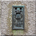
Flush Bracket, Hilltown
Flush bracket bench mark located on the front of the disused St John's Church in the centre of Hilltown Image The number on the bracket is OSBM 3560. The mark has been levelled to 131.32 metres above MSL. The mark is located at the bottom of the church tower, however the church is surrounded by a high wall and fence; it took some work to find a suitable place to both scale this and then leave.
Image: © Rossographer Taken: 3 Jul 2017
0.09 miles
7
Minny Doyle's Bar, Hilltown
Image: © Eric Jones Taken: 2 Apr 2011
0.09 miles
8
Rostrevor Road, Hilltown
The building on the left is St John's CoI Church.
Image: © Eric Jones Taken: 17 Jul 2010
0.09 miles
9
Minni Doyle's Bar, Hilltown
Image: © Eric Jones Taken: 8 Aug 2015
0.10 miles
10
Guinness Adverts on the front of Minny Doyle's Bar in Hilltown
Image: © Eric Jones Taken: 9 May 2016
0.10 miles
  • ...