IMAGES TAKEN NEAR TO
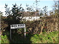
Bog Road, NEWRY, BT34 5TH
Introduction
This page details the photographs taken nearby to Bog Road, BT34 5TH by members of the Geograph project.
The Geograph project started in 2005 with the aim of publishing, organising and preserving representative images for every square kilometre of Great Britain, Ireland and the Isle of Man.

There are currently over 7.5m images from over14,400 individuals and you can help contribute to the project by visiting https://www.geograph.org.uk
Image Map
Images are licensed for reuse under creativecommons.org/licenses/by-sa/2.0
Notes
- Clicking on the map will re-center to the selected point.
- The higher the marker number, the further away the image location is from the centre of the postcode.
Image Listing (7 Images Found)
Images are licensed for reuse under creativecommons.org/licenses/by-sa/2.0
Image
Details
Distance
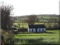
2
Rear view of the cottage on the corner of Bog Road and Cross Road
Image: © Eric Jones
Taken: 5 Nov 2011
0.15 miles
3
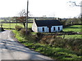
Cottage at the junction of Cross Road and Bog Road
This is in the townland of Ballygorian More.
Image: © Eric Jones
Taken: 5 Nov 2011
0.16 miles
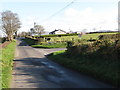
4
The Cross Road Cross Roads
The road to the right leading off Cross Road is the Bog Road. That to the left, the Ballygorian Road, leads to Hilltown.
Image: © Eric Jones
Taken: 5 Nov 2011
0.16 miles
5
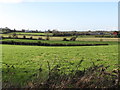
View south towards the cross roads on the Cross Road
Tamary Hill forms the background.
Image: © Eric Jones
Taken: 5 Nov 2011
0.17 miles
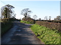
6
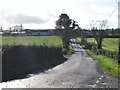
The Bog Road at the junction with Tamary Hill
This is in the townland of Ballygorian More.
Image: © Eric Jones
Taken: 5 Nov 2011
0.20 miles
7
The Bog Road at the junction with Drumlough Cross Road
Drumlough Orange Hall stands on the brow of the hill.
Image: © Eric Jones
Taken: 5 Nov 2011
0.22 miles