IMAGES TAKEN NEAR TO
St. Annes Terrace, NEWRY, BT34 5RJ
Introduction
This page details the photographs taken nearby to St. Annes Terrace, BT34 5RJ by members of the Geograph project.
The Geograph project started in 2005 with the aim of publishing, organising and preserving representative images for every square kilometre of Great Britain, Ireland and the Isle of Man.

There are currently over 7.5m images from over14,400 individuals and you can help contribute to the project by visiting https://www.geograph.org.uk
Image Map
Images are licensed for reuse under creativecommons.org/licenses/by-sa/2.0
Notes
- Clicking on the map will re-center to the selected point.
- The higher the marker number, the further away the image location is from the centre of the postcode.
Image Listing (29 Images Found)
Images are licensed for reuse under creativecommons.org/licenses/by-sa/2.0
Image
Details
Distance
1
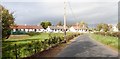
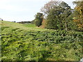
Bungalows at Cabra
The hamlet of Cabra lies off the A25 between Kilcoo and McCombs Bridge.
Image: © Eric Jones
Taken: 9 Oct 2018
0.01 miles
2
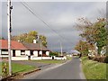
Semi-detached bungalows off the Cabra Road
Image: © Eric Jones
Taken: 9 Oct 2018
0.02 miles
4
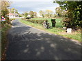
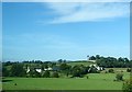
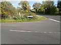
The southern end of Cabra Road, Cabra
The image was taken from the A25 (Rathfriland-Castlewellan Road). The stone marks the southern boundary of Cabra TD.
Image: © Eric Jones
Taken: 9 Oct 2018
0.07 miles
5
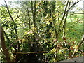
The Cabra River west of the Cabra Road
This river flows into the Muddock River, a major tributary of the River Bann.
Image: © Eric Jones
Taken: 9 Oct 2018
0.07 miles
6
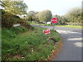
Cabra Crossroads on the A25
The image was taken across the A25 from Kinghill Road towards Cabra Road.
Image: © Eric Jones
Taken: 9 Oct 2018
0.08 miles
7
The Cabra River below the Cabra Road bridge
Image: © Eric Jones
Taken: 9 Oct 2018
0.08 miles
9
The junction of Kinghill Road and the A25 at Cabra Crossroads
A school bus shelter stands on the opposite side of the A25. Apart from school buses, stopping bus services along this stretch of the A25 are, to say the least, sketchy.
Image: © Eric Jones
Taken: 9 Oct 2018
0.09 miles
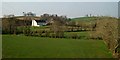
10
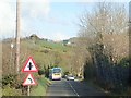
Perils of the A25
This regional arterial road serves South Armagh and South Down winding its way through drumlin country.
Image: © Eric Jones
Taken: 9 Apr 2018
0.09 miles