IMAGES TAKEN NEAR TO
Bannfield Road, NEWRY, BT34 5PJ
Introduction
This page details the photographs taken nearby to Bannfield Road, BT34 5PJ by members of the Geograph project.
The Geograph project started in 2005 with the aim of publishing, organising and preserving representative images for every square kilometre of Great Britain, Ireland and the Isle of Man.

There are currently over 7.5m images from over14,400 individuals and you can help contribute to the project by visiting https://www.geograph.org.uk
Image Map
Images are licensed for reuse under creativecommons.org/licenses/by-sa/2.0
Notes
- Clicking on the map will re-center to the selected point.
- The higher the marker number, the further away the image location is from the centre of the postcode.
Image Listing (10 Images Found)
Images are licensed for reuse under creativecommons.org/licenses/by-sa/2.0
Image
Details
Distance
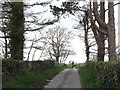
1

Bannfield Road at the junction with Moneygore Road
Image: © Eric Jones
Taken: 4 May 2013
0.15 miles

3
The Moneygore Road bridge over the River Bann
Image: © Eric Jones
Taken: 4 May 2013
0.17 miles
4
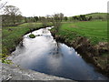
The meandering Bann above Bannfield Bridge
The image was taken from the Moneygore Road.
Image: © Eric Jones
Taken: 4 May 2013
0.19 miles
5
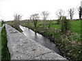
The Bann below Bannfield Bridge
The image was taken from the Moneygore Road.
Image: © Eric Jones
Taken: 4 May 2013
0.19 miles
7
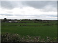
Farmland between School Road and Bannfield Road
This is drumlin country with heavy soils which favour pastoral agriculture.
Image: © Eric Jones
Taken: 4 May 2013
0.20 miles
8
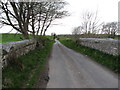
The Moneygore Road west of Bannfield Bridge
Image: © Eric Jones
Taken: 4 May 2013
0.24 miles
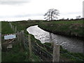
9
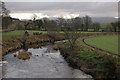
The River Bann near Rathfriland (1)
The River Bann rises near Spelga Dam in the Mournes and is still in its infancy by the time it reaches Rathfriland. This is the view upstream from the Bannfield Bridge, on the Moneygore Road, to the east of Rathfriland. The cloud-capped Mournes can be seen in the distance.
Image: © Albert Bridge
Taken: 24 Jan 2007
0.24 miles
10
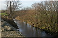
The River Bann near Rathfriland (2)
See Image The Bann makes a sharp turn as it passes under the Bannfield Bridge. This is the view downstream with the wall of the bridge on the left.
Image: © Albert Bridge
Taken: 24 Jan 2007
0.24 miles