IMAGES TAKEN NEAR TO
Lisnacroppan Road, NEWRY, BT34 5NZ
Introduction
This page details the photographs taken nearby to Lisnacroppan Road, BT34 5NZ by members of the Geograph project.
The Geograph project started in 2005 with the aim of publishing, organising and preserving representative images for every square kilometre of Great Britain, Ireland and the Isle of Man.

There are currently over 7.5m images from over14,400 individuals and you can help contribute to the project by visiting https://www.geograph.org.uk
Image Map
Images are licensed for reuse under creativecommons.org/licenses/by-sa/2.0
Notes
- Clicking on the map will re-center to the selected point.
- The higher the marker number, the further away the image location is from the centre of the postcode.
Image Listing (5 Images Found)
Images are licensed for reuse under creativecommons.org/licenses/by-sa/2.0
Image
Details
Distance
1
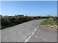
View westwards along Lisnacroppan Road from the mouth of Knock Road
Image: © Eric Jones
Taken: 28 Mar 2012
0.17 miles
2
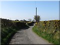
The angular southern end of Knock Road
Knock Road, which hugs the hillside, has a number of Z-bends.
Image: © Eric Jones
Taken: 28 Mar 2012
0.20 miles
3
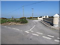
The southern end of Knock Road
This image was taken on Lisnacroppan Road
Image: © Eric Jones
Taken: 28 Mar 2012
0.20 miles
4
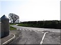
Knock Road at its junction with Lisnacroppan Road
The road sign reads Lisnacroppin, but the OSNI and Google use Lisnacroppan.
Image: © Eric Jones
Taken: 28 Mar 2012
0.21 miles
5
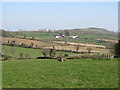
Farm on slopes below Lisnacroppan Road
The hill in the background is Knockiveagh.
Image: © Eric Jones
Taken: 28 Mar 2012
0.22 miles