IMAGES TAKEN NEAR TO
Lisnacroppan Road, NEWRY, BT34 5NY
Introduction
This page details the photographs taken nearby to Lisnacroppan Road, BT34 5NY by members of the Geograph project.
The Geograph project started in 2005 with the aim of publishing, organising and preserving representative images for every square kilometre of Great Britain, Ireland and the Isle of Man.

There are currently over 7.5m images from over14,400 individuals and you can help contribute to the project by visiting https://www.geograph.org.uk
Image Map
Images are licensed for reuse under creativecommons.org/licenses/by-sa/2.0
Notes
- Clicking on the map will re-center to the selected point.
- The higher the marker number, the further away the image location is from the centre of the postcode.
Image Listing (16 Images Found)
Images are licensed for reuse under creativecommons.org/licenses/by-sa/2.0
Image
Details
Distance
1
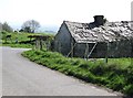
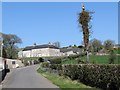
Derelict cottage at the ninety degree bend in Lisnacroppan Road
Image: © Eric Jones
Taken: 28 Mar 2012
0.02 miles
2
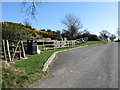
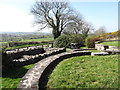
The Bronte Homeland Picnic Site
This picnic spot, on Lisnacroppan Road, provides an excellent view over the area between Knockiveagh Hill and the Mournes.
Image: © Eric Jones
Taken: 28 Mar 2012
0.12 miles
3
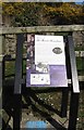
A Bronte Homeland Trail Information Board
This stands at the Bronte picnic spot which overlooks the upper Clanrye Valley and the Mountains of Mourne.
Image: © Eric Jones
Taken: 28 Mar 2012
0.12 miles
4
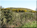
The whin-covered subsidiary summit of Knockiveagh
Image: © Eric Jones
Taken: 28 Mar 2012
0.13 miles
5
The Bronte Homeland Picnic Site on Lisnacroppan Road
This site provides a fine view of an undulating countryside extending southwards towards the Mourne Mountains.
Image: © Eric Jones
Taken: 28 Mar 2012
0.14 miles
7
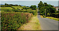
The Lisnacroppin Road near Rathfriland
The Lisnacroppin (“Lisnacroppan” on the Google map) Road is a minor road running across country, through the drumlins, to the northwest of Rathfriland. The Dromara Hills can be seen in the distance.
Image: © Albert Bridge
Taken: 2 Jul 2010
0.16 miles
8
The summit of Knockiveagh from the Lisnacroppan Road
Image: © Eric Jones
Taken: 28 Mar 2012
0.17 miles
9
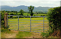
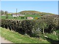
Gate near Rathfriland
A field gate, on the Lisnacroppin Road Image with a view of the Mournes.
Image: © Albert Bridge
Taken: 2 Jul 2010
0.17 miles
10
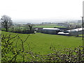
Settlement at Edenagarry
This is strung along Lisnacroppan Road.
Image: © Eric Jones
Taken: 28 Mar 2012
0.18 miles