IMAGES TAKEN NEAR TO
Millvale Road, NEWRY, BT34 5NT
Introduction
This page details the photographs taken nearby to Millvale Road, BT34 5NT by members of the Geograph project.
The Geograph project started in 2005 with the aim of publishing, organising and preserving representative images for every square kilometre of Great Britain, Ireland and the Isle of Man.

There are currently over 7.5m images from over14,400 individuals and you can help contribute to the project by visiting https://www.geograph.org.uk
Image Map
Images are licensed for reuse under creativecommons.org/licenses/by-sa/2.0
Notes
- Clicking on the map will re-center to the selected point.
- The higher the marker number, the further away the image location is from the centre of the postcode.
Image Listing (8 Images Found)
Images are licensed for reuse under creativecommons.org/licenses/by-sa/2.0
Image
Details
Distance
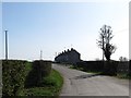
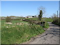
2
View west towards a sharp bend in Millvale Road
Image: © Eric Jones
Taken: 28 Mar 2012
0.04 miles
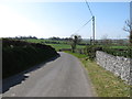
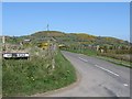
4
A Z-bend in Millvale Road
The whin covered Knockiveagh can be seen in the background.
Image: © Eric Jones
Taken: 28 Mar 2012
0.06 miles
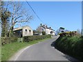
5
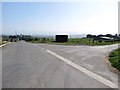
The northern end of Millvale Road from the Lisnacroppan Road
The squarish structure at the junction is the school bus shelter. No scheduled Ulsterbus service serves Edenagarry.
Image: © Eric Jones
Taken: 28 Mar 2012
0.20 miles
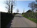
6
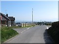
Cross Roads on the Lisnacroppan Road at Edenagarry
Here, the Lisnacroppan Road is joined, from the left, by Iveagh Road, and, from the right, by Millvale Road. In the background, the outline of the Mournes can be seen in the haze.
Image: © Eric Jones
Taken: 28 Mar 2012
0.21 miles
7
View north along Iveagh Road
The whin-covered Knockiveagh dominates the skyline.
Image: © Eric Jones
Taken: 28 Mar 2012
0.24 miles