IMAGES TAKEN NEAR TO
Banbridge Road, NEWRY, BT34 5NR
Introduction
This page details the photographs taken nearby to Banbridge Road, BT34 5NR by members of the Geograph project.
The Geograph project started in 2005 with the aim of publishing, organising and preserving representative images for every square kilometre of Great Britain, Ireland and the Isle of Man.

There are currently over 7.5m images from over14,400 individuals and you can help contribute to the project by visiting https://www.geograph.org.uk
Image Map
Images are licensed for reuse under creativecommons.org/licenses/by-sa/2.0
Notes
- Clicking on the map will re-center to the selected point.
- The higher the marker number, the further away the image location is from the centre of the postcode.
Image Listing (3 Images Found)
Images are licensed for reuse under creativecommons.org/licenses/by-sa/2.0
Image
Details
Distance
1
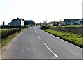
Farmhouse on the Banbridge Road south of The Diamond
Image: © Eric Jones
Taken: 28 Mar 2012
0.02 miles
2
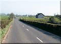
The B10 (May's Corner Road) approaching a major junction with the Katesbridge Road at the Diamond
Image: © Eric Jones
Taken: 28 Mar 2012
0.16 miles
3
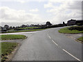
Mays Corner road (B10)
Approaching the junction with the Greenhill road on the left travelling towards Rathfriland.
Image: © Terry Stewart
Taken: 10 Sep 2007
0.25 miles