IMAGES TAKEN NEAR TO
Bog Road, NEWRY, BT34 5JW
Introduction
This page details the photographs taken nearby to Bog Road, BT34 5JW by members of the Geograph project.
The Geograph project started in 2005 with the aim of publishing, organising and preserving representative images for every square kilometre of Great Britain, Ireland and the Isle of Man.

There are currently over 7.5m images from over14,400 individuals and you can help contribute to the project by visiting https://www.geograph.org.uk
Image Map
Images are licensed for reuse under creativecommons.org/licenses/by-sa/2.0
Notes
- Clicking on the map will re-center to the selected point.
- The higher the marker number, the further away the image location is from the centre of the postcode.
Image Listing (6 Images Found)
Images are licensed for reuse under creativecommons.org/licenses/by-sa/2.0
Image
Details
Distance
1
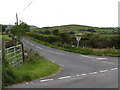
The mouth of the southern section of Bog Road from its intersection by Tullyree Road
Image: © Eric Jones
Taken: 2 Jul 2011
0.10 miles
3
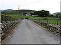
Farm access lane off Tullyree Road
This private road which links the Tullyree and Bryansford Road provides access to a number of farms and houses.
Image: © Eric Jones
Taken: 2 Jul 2011
0.15 miles
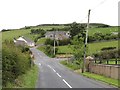
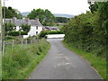
4
Houses on the Bog Road
The image was taken from the Tullyree Road.
Image: © Eric Jones
Taken: 2 Jul 2011
0.20 miles
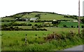
5
The junction of Drumena Road and Tullyree Road east of Kilcoo
Image: © Eric Jones
Taken: 2 Jul 2011
0.22 miles
6
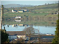
Loch Inse Riabhai - Lough Island Reavy
Loch Inse Riabhi - Loch of the Grey Island
Image: © Kevin O'Kane
Taken: 24 Dec 2005
0.23 miles