IMAGES TAKEN NEAR TO
Ballymoney Road, NEWRY, BT34 5HU
Introduction
This page details the photographs taken nearby to Ballymoney Road, BT34 5HU by members of the Geograph project.
The Geograph project started in 2005 with the aim of publishing, organising and preserving representative images for every square kilometre of Great Britain, Ireland and the Isle of Man.

There are currently over 7.5m images from over14,400 individuals and you can help contribute to the project by visiting https://www.geograph.org.uk
Image Map
Images are licensed for reuse under creativecommons.org/licenses/by-sa/2.0
Notes
- Clicking on the map will re-center to the selected point.
- The higher the marker number, the further away the image location is from the centre of the postcode.
Image Listing (25 Images Found)
Images are licensed for reuse under creativecommons.org/licenses/by-sa/2.0
Image
Details
Distance

2
Cill Chua - Kilcoo
Cill Chua - Church of the Hollow
Image: © Kevin O'Kane
Taken: 24 Dec 2005
0.11 miles
3
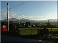
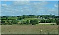
View across the Kilcoo Plain towards Tullynasoo Mountain
Tullynasoo Mountain, like the Slieve Croob range behind it, is formed of granodiorites of the Newry Igneous Complex dated by the Rubidium-strontium method at 399±3Ma.
Image: © Eric Jones
Taken: 10 Apr 2019
0.13 miles
4
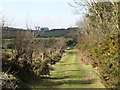
Green lane leading to a ruined church
This green lane is classified as a public footpath. In Ireland, North and South, public footpaths are scarcer than hen's teeth.
Image: © Eric Jones
Taken: 26 Mar 2011
0.16 miles
5
Entering the townland of Baile Muine/Ballymoney
The parapet of the bridge is painted in black and white - the colours of Kilcoo GAC (Gaelic Athletics Club).
http://www.downgaa.net/downgaa/clubs/kilcoo/kilcoo.htm
Image: © Eric Jones
Taken: 26 Mar 2011
0.17 miles
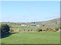
6
The grounds of Kilcoo Gaelic Athletic Club
These are located below the western dam of the Lough Island Reavy reservoir.
Image: © Eric Jones
Taken: 3 Jul 2019
0.18 miles
7

Rainbow over Kilcoo
Looks like the rainbow going into the house...
Image: © GARRY HARPER
Taken: 24 Jul 2009
0.19 miles
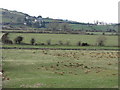
8
The Kilcoo GAC Ground
This is located below the southwestern dam of the Lough Island Reavy reservoir.
Image: © Eric Jones
Taken: 10 Apr 2019
0.20 miles
9
Owen Roe GAC, Kilcoo
This is located beneath the dam wall of the Lough Island Reavy reservoir.
Image: © Eric Jones
Taken: 9 Jun 2021
0.20 miles
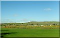
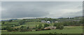
10
View south-west across the Muddock flood plain
This image was taken from the Ballymoney Road. The Dublin Road (A25) can be seen on the hill side opposite.
Image: © Eric Jones
Taken: 26 Mar 2011
0.21 miles