IMAGES TAKEN NEAR TO
Mill Road, NEWRY, BT34 5HD
Introduction
This page details the photographs taken nearby to Mill Road, BT34 5HD by members of the Geograph project.
The Geograph project started in 2005 with the aim of publishing, organising and preserving representative images for every square kilometre of Great Britain, Ireland and the Isle of Man.

There are currently over 7.5m images from over14,400 individuals and you can help contribute to the project by visiting https://www.geograph.org.uk
Image Map
Images are licensed for reuse under creativecommons.org/licenses/by-sa/2.0
Notes
- Clicking on the map will re-center to the selected point.
- The higher the marker number, the further away the image location is from the centre of the postcode.
Image Listing (6 Images Found)
Images are licensed for reuse under creativecommons.org/licenses/by-sa/2.0
Image
Details
Distance
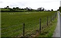
2
Access road linking a converted barn to the Mill Road
Image: © Eric Jones
Taken: 16 May 2012
0.17 miles
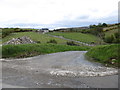
3

The meandering Muddock River from Mill Road
Image: © Eric Jones
Taken: 16 May 2012
0.19 miles
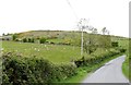
5
New residence overlooking the Muddock Valley
This appears to be a farm building conversion on the site of a traditional homestead.
Image: © Eric Jones
Taken: 16 May 2012
0.21 miles
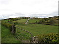
6

Linear settlement along Mill Road
New houses have replaced most of the former traditional homestead cottages in this area. The water body in the background is the Lough Island Reavy reservoir.
Image
Image: © Eric Jones
Taken: 16 May 2012
0.22 miles