IMAGES TAKEN NEAR TO
Carn Valley, NEWRY, BT34 5GA
Introduction
This page details the photographs taken nearby to Carn Valley, BT34 5GA by members of the Geograph project.
The Geograph project started in 2005 with the aim of publishing, organising and preserving representative images for every square kilometre of Great Britain, Ireland and the Isle of Man.

There are currently over 7.5m images from over14,400 individuals and you can help contribute to the project by visiting https://www.geograph.org.uk
Image Map
Images are licensed for reuse under creativecommons.org/licenses/by-sa/2.0
Notes
- Clicking on the map will re-center to the selected point.
- The higher the marker number, the further away the image location is from the centre of the postcode.
Image Listing (70 Images Found)
Images are licensed for reuse under creativecommons.org/licenses/by-sa/2.0
Image
Details
Distance
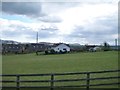
1
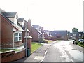
Bungalows on the Carn Valley Estate
This estate is located off the Hilltown Road.
Image: © Eric Jones
Taken: 17 Jul 2010
0.06 miles
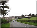
2
The Carn Valley Estate from the Hilltown Road
Image: © Eric Jones
Taken: 20 Feb 2010
0.07 miles
3

Where town and country meet - The Carn Estate, Rathfriland
This is a recently built housing estate at the eastern fringe of the town of Rathfriland. The image was taken from the A25.
Image: © Eric Jones
Taken: 5 Jul 2016
0.07 miles
4
A25 Castlewellan Road, Rathfriland
Image: © Jo and Steve Turner
Taken: 3 Sep 2006
0.08 miles
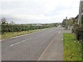
5
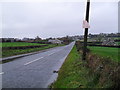
Castlewellan Road at Drumarkin
Looking towards Rathfriland. Townland of Drumarkin.
Image: © Dean Molyneaux
Taken: 29 Oct 2009
0.08 miles
6
Entering Rathfriland on the A25 from the direction of Castlewellan
Image: © Eric Jones
Taken: 4 May 2013
0.09 miles
7
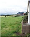
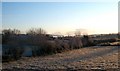
Farm buildings on the outskirts of Rathfriland
Image: © Eric Jones
Taken: 17 Jul 2010
0.09 miles
8
Houses on the Carn Valley Estate
This image was taken from the A25.
Image: © Eric Jones
Taken: 14 Apr 2012
0.09 miles
9
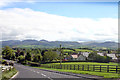
View East along the A25 (Castlewellan Road)
This image was taken on the eastern fringe of the town of Rathfriland. The Slieve Croob and Tullynasoo Mountains can be seen in the background.
Image: © Eric Jones
Taken: 9 Oct 2018
0.10 miles
10
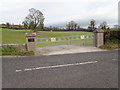
The Queen Elizabeth II Ornamental Gates leading to the Rathfriland Loyal Orange Lodge No 3 Memorial Grounds
These lead in from the A25.
Image: © Eric Jones
Taken: 9 Oct 2018
0.10 miles